Kubu geodata
Kubu (Bali) is a seat of a third-order administrative division; located in Indonesia in Asia/Makassar (GMT+8) time zone. In our database, there are 407 cities with bigger population. Compared to other cities in Indonesia, 74.4% of cities are located further ↑North; 75.3% of cities are located further ←West and 61.1% of cities have higher elevation than Kubu. Note1


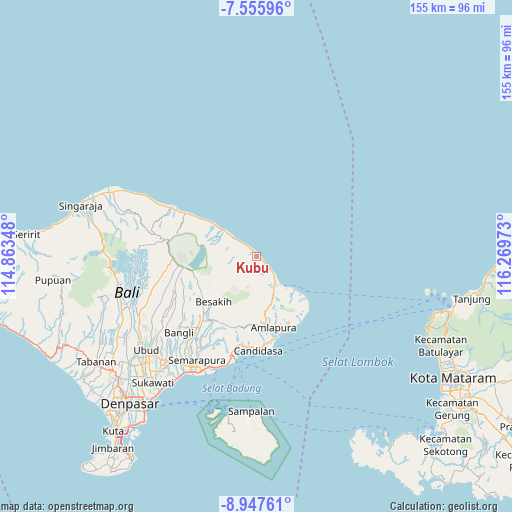
Kubu GPS coordinates[2]
8° 15' 8.64" South, 115° 33' 59.76" East
| Map corner | latitude | longitude |
|---|---|---|
| Upper-left | -7.55596°, | 114.86348° |
| Center: | -8.2524°, | 115.5666° |
| Lower-right: | -8.94761°, | 116.26973° |
| Map W x H: | 154.7×154.7 km | = 96.1×96.1mi |
| max Lat: | 5.88969° ⇑74.4% North |
| Kubu: | -8.2524° |
| min Lat: | ⇓25.6% South -10.934° |
| min Long | Kubu | max Long |
| 95.1345° | 115.5666° | 140.9419° |
| W 75.3%⇐ | ⇒24.7% E |
Elevation
Elevation of Kubu is 55 m = 180 ft, and this is 174.7 m = 573 ft below average elevation for this country.
| Max E: |
3185 m = 10449 ft | 61.1% |
| Avg. | 229.7 m = 754 ft | |
| Kubu | 55 m = 180 ft | |
Min E: |
-1 m = -3 ft | 38.9% |
See also: Indonesia elevation on elevation.city.
Geographical zone
Kubu is located in South Torrid zone (between Equator and Tropic of Capricorn). Distance of Equator is 917.6 km =570.2 mi to North.| Distance of | km | miles | from Kubu |
|---|---|---|---|
| Equator | 917.6 | 570.2 | to North |
| Tropic Capricorn | 1688.3 | 1049.1 | to South |
| Antarctic Circle | 6483.6 | 4028.7 | to South |
| South Pole | 9089.5 | 5648 | to South |


Nearby cities:
15 places around Kubu: (largest is in red/bold)
• Abang
15.4 km =9.6 mi,  165°
165°
• Banjar Ababi
17.2 km =10.7 mi, 173°
• Banjar Bau Kawan
14.4 km =8.9 mi, 172°
• Banjar Buayang
11.6 km =7.2 mi,  153°
153°
• Banjar Dukuh
3.7 km =2.3 mi,  206°
206°
• Banjar Kangkaang
12.7 km =7.9 mi,  156°
156°
• Banjar Kelodan
10.5 km =6.5 mi, 161°
• Banjar Kubu
0.5 km =0.3 mi,  110°
110°
• Banjar Trunyan
15.5 km =9.6 mi,  270°
270°
• Baturinggit Kaja
0.8 km =0.5 mi,  330°
330°
• Biaslantang Kaler
11.5 km =7.1 mi,  143°
143°
• Penggakrajeng
9.8 km =6.1 mi, 144°
• Sukadana
3.9 km =2.4 mi,  315°
315°
• Tistagede
14.9 km =9.3 mi, 161°
• Tiyingtali Kelod
18.5 km =11.5 mi, 163°
Sources, notices
• [Note1] Compared only with cities in Indonesia existing in our database
• [Src1] Map data: © OpenStreetMap contributors (CC-BY-SA)
• [Src2] Other city data from geonames.org with taken over terms of usage.
• [Src3] Geographical zone / Annual Mean Temperature by Robert A. Rohde @ Wikipedia
