Tebara geodata
Tebara (East Nusa Tenggara) is a seat of a fourth-order administrative division; located in Indonesia in Asia/Makassar (GMT+8) time zone. In our database, there are 407 cities with bigger population. Compared to other cities in Indonesia, 94.2% of cities are located further ↑North; 81.7% of cities are located further ←West and 79.5% of cities have lower elevation than Tebara. Note1


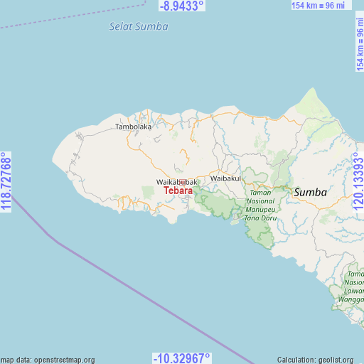
Tebara GPS coordinates[2]
9° 38' 13.92" South, 119° 25' 50.88" East
| Map corner | latitude | longitude |
|---|---|---|
| Upper-left | -8.9433°, | 118.72768° |
| Center: | -9.6372°, | 119.4308° |
| Lower-right: | -10.32967°, | 120.13393° |
| Map W x H: | 154.1×154.2 km | = 95.8×95.8mi |
| max Lat: | 5.88969° ⇑94.2% North |
| Tebara: | -9.6372° |
| min Lat: | ⇓5.8% South -10.934° |
| min Long | Tebara | max Long |
| 95.1345° | 119.4308° | 140.9419° |
| W 81.7%⇐ | ⇒18.3% E |
Elevation
Elevation of Tebara is 425 m = 1394 ft, and this is 195.3 m = 641 ft above average elevation for this country.
| Max E: |
3185 m = 10449 ft | 20.5% |
| Tebara | 425 m 1394 ft | |
| Avg. | 229.7 m = 754 ft | |
Min E: |
-1 m = -3 ft | 79.5% |
See also: Indonesia elevation on elevation.city.
Geographical zone
Tebara is located in South Torrid zone (between Equator and Tropic of Capricorn). Distance of Equator is 1071.6 km =665.9 mi to North.| Distance of | km | miles | from Tebara |
|---|---|---|---|
| Equator | 1071.6 | 665.9 | to North |
| Tropic Capricorn | 1534.4 | 953.4 | to South |
| Antarctic Circle | 6329.6 | 3933 | to South |
| South Pole | 8935.5 | 5552.3 | to South |


Nearby cities:
15 places around Tebara: (largest is in red/bold)
• Andekantor
9.3 km =5.8 mi,  311°
311°
• Barabedang
6.9 km =4.3 mi,  156°
156°
• Kalimbukuni
0.6 km =0.4 mi,  79°
79°
• Komerda
2.3 km =1.4 mi,  283°
283°
• Kotawaikabubak
0.9 km =0.6 mi,  267°
267°
• Litibakul
7 km =4.3 mi,  175°
175°
• Ngaduloda
9 km =5.6 mi,  227°
227°
• Puukadelu
2.8 km =1.7 mi,  236°
236°
• Tibutana
0.7 km =0.4 mi, 305°
• Toupopu
8.6 km =5.3 mi,  148°
148°
• Waibakul
1.9 km =1.2 mi, 275°
• Waikabubak
4.7 km =2.9 mi,  255°
255°
• Wailiang
2.6 km =1.6 mi, 274°
• Waimadaka
8.2 km =5.1 mi,  195°
195°
• Weepanapi
7.2 km =4.5 mi,  12°
12°
Sources, notices
• [Note1] Compared only with cities in Indonesia existing in our database
• [Src1] Map data: © OpenStreetMap contributors (CC-BY-SA)
• [Src2] Other city data from geonames.org with taken over terms of usage.
• [Src3] Geographical zone / Annual Mean Temperature by Robert A. Rohde @ Wikipedia
