Laiponda geodata
Laiponda (East Nusa Tenggara) is a seat of a fourth-order administrative division; located in Indonesia in Asia/Makassar (GMT+8) time zone. In our database, there are 407 cities with bigger population. Compared to other cities in Indonesia, 96% of cities are located further ↑North; 82.5% of cities are located further ←West and 74.8% of cities have lower elevation than Laiponda. Note1


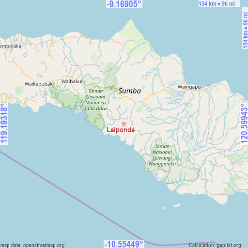
Laiponda GPS coordinates[2]
9° 51' 45" South, 119° 53' 46.68" East
| Map corner | latitude | longitude |
|---|---|---|
| Upper-left | -9.16905°, | 119.19318° |
| Center: | -9.8625°, | 119.8963° |
| Lower-right: | -10.55449°, | 120.59943° |
| Map W x H: | 154×154 km | = 95.7×95.7mi |
| max Lat: | 5.88969° ⇑96% North |
| Laiponda: | -9.8625° |
| min Lat: | ⇓4% South -10.934° |
| min Long | Laiponda | max Long |
| 95.1345° | 119.8963° | 140.9419° |
| W 82.5%⇐ | ⇒17.5% E |
Elevation
Elevation of Laiponda is 357 m = 1171 ft, and this is 127.3 m = 418 ft above average elevation for this country.
| Max E: |
3185 m = 10449 ft | 25.2% |
| Laiponda | 357 m 1171 ft | |
| Avg. | 229.7 m = 754 ft | |
Min E: |
-1 m = -3 ft | 74.8% |
See also: Indonesia elevation on elevation.city.
Geographical zone
Laiponda is located in South Torrid zone (between Equator and Tropic of Capricorn). Distance of Equator is 1096.6 km =681.4 mi to North.| Distance of | km | miles | from Laiponda |
|---|---|---|---|
| Equator | 1096.6 | 681.4 | to North |
| Tropic Capricorn | 1509.3 | 937.8 | to South |
| Antarctic Circle | 6304.6 | 3917.5 | to South |
| South Pole | 8910.5 | 5536.7 | to South |


Nearby cities:
15 places around Laiponda: (largest is in red/bold)
• Bidikotak
31.5 km =19.6 mi,  83°
83°
• Billa
22 km =13.7 mi,  115°
115°
• Kanjilu
20 km =12.4 mi,  62°
62°
• Karipidita
22.1 km =13.7 mi,  41°
41°
• Karita
23.6 km =14.7 mi,  108°
108°
• Kombapari
9.6 km =6 mi,  28°
28°
• Malahar
21.5 km =13.4 mi, 116°
• Ngarangiakambera
24.4 km =15.2 mi, 29°
• Pahomba
28.6 km =17.8 mi,  338°
338°
• Prailangina
29 km =18 mi,  325°
325°
• Praingkareha
23.4 km =14.5 mi,  135°
135°
• Tarimbang
13.5 km =8.4 mi,  152°
152°
• Wahang Dua
29.6 km =18.4 mi, 150°
• Wairinding
33.1 km =20.6 mi,  50°
50°
• Walakeri
29.1 km =18.1 mi, 106°
Sources, notices
• [Note1] Compared only with cities in Indonesia existing in our database
• [Src1] Map data: © OpenStreetMap contributors (CC-BY-SA)
• [Src2] Other city data from geonames.org with taken over terms of usage.
• [Src3] Geographical zone / Annual Mean Temperature by Robert A. Rohde @ Wikipedia
