Putat Lor geodata
Putat Lor (East Java) is a seat of a fourth-order administrative division; located in Indonesia in Asia/Jakarta (GMT+7) time zone. In our database, there are 407 cities with bigger population. Compared to other cities in Indonesia, 68.9% of cities are located further ↑North; 56.4% of cities are located further ←West and 77.1% of cities have lower elevation than Putat Lor. Note1


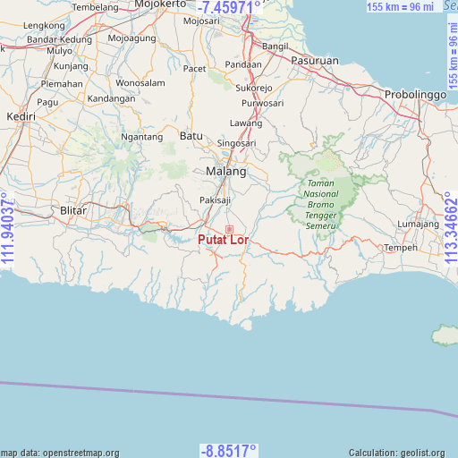
Putat Lor GPS coordinates[2]
8° 9' 22.716" South, 112° 38' 36.564" East
| Map corner | latitude | longitude |
|---|---|---|
| Upper-left | -7.45971°, | 111.94037° |
| Center: | -8.15631°, | 112.64349° |
| Lower-right: | -8.8517°, | 113.34662° |
| Map W x H: | 154.8×154.8 km | = 96.2×96.2mi |
| max Lat: | 5.88969° ⇑68.9% North |
| Putat Lor: | -8.15631° |
| min Lat: | ⇓31.1% South -10.934° |
| min Long | Putat Lor | max Long |
| 95.1345° | 112.64349° | 140.9419° |
| W 56.4%⇐ | ⇒43.6% E |
Elevation
Elevation of Putat Lor is 386 m = 1266 ft, and this is 156.3 m = 513 ft above average elevation for this country.
| Max E: |
3185 m = 10449 ft | 22.9% |
| Putat Lor | 386 m 1266 ft | |
| Avg. | 229.7 m = 754 ft | |
Min E: |
-1 m = -3 ft | 77.1% |
See also: Indonesia elevation on elevation.city.
Geographical zone
Putat Lor is located in South Torrid zone (between Equator and Tropic of Capricorn). Distance of Equator is 906.9 km =563.5 mi to North.| Distance of | km | miles | from Putat Lor |
|---|---|---|---|
| Equator | 906.9 | 563.5 | to North |
| Tropic Capricorn | 1699 | 1055.7 | to South |
| Antarctic Circle | 6494.3 | 4035.4 | to South |
| South Pole | 9100.2 | 5654.6 | to South |


Nearby cities:
15 places around Putat Lor: (largest is in red/bold)
• Banjarejokrajan
3.5 km =2.2 mi,  215°
215°
• Ganjaran
3.6 km =2.2 mi,  297°
297°
• Gondanglegi Wetan
2.6 km =1.6 mi,  186°
186°
• Gongdanglegi Kulon
2.3 km =1.4 mi,  201°
201°
• Jeru
3.6 km =2.2 mi,  99°
99°
• Ketawang
1.7 km =1.1 mi,  0°
0°
• Panggungrejo
4.8 km =3 mi,  284°
284°
• Putat Kidul
2 km =1.2 mi,  176°
176°
• Putukrejo
3.6 km =2.2 mi,  340°
340°
• Sepanjang
2.6 km =1.6 mi,  126°
126°
• Sudimoro
4.9 km =3 mi,  41°
41°
• Sukosarikrajan
4.7 km =2.9 mi,  264°
264°
• Tanggung
4.1 km =2.5 mi,  113°
113°
• Turen
5 km =3.1 mi, 111°
• Urek-urek
2.8 km =1.7 mi,  54°
54°
Sources, notices
• [Note1] Compared only with cities in Indonesia existing in our database
• [Src1] Map data: © OpenStreetMap contributors (CC-BY-SA)
• [Src2] Other city data from geonames.org with taken over terms of usage.
• [Src3] Geographical zone / Annual Mean Temperature by Robert A. Rohde @ Wikipedia
