Panggungrejo geodata
Panggungrejo (East Java) is a seat of a fourth-order administrative division; located in Indonesia in Asia/Jakarta (GMT+7) time zone. In our database, there are 407 cities with bigger population. Compared to other cities in Indonesia, 68.3% of cities are located further ↑North; 56.1% of cities are located further ←West and 74.4% of cities have lower elevation than Panggungrejo. Note1


Panggungrejo GPS coordinates[2]
8° 8' 43.8" South, 112° 36' 3.24" East
| Map corner | latitude | longitude |
|---|---|---|
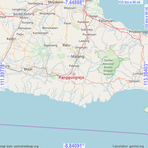
| Upper-left | -7.44888°, | 111.89778° |
| Center: | -8.1455°, | 112.6009° |
| Lower-right: | -8.84091°, | 113.30403° |
| Map W x H: | 154.8×154.8 km | = 96.2×96.2mi |
| max Lat: | 5.88969° ⇑68.3% North |
| Panggungrejo: | -8.1455° |
| min Lat: | ⇓31.7% South -10.934° |
| min Long | Panggungrejo | max Long |
| 95.1345° | 112.6009° | 140.9419° |
| W 56.1%⇐ | ⇒43.9% E |
Elevation
Elevation of Panggungrejo is 351 m = 1152 ft, and this is 121.3 m = 398 ft above average elevation for this country.
| Max E: |
3185 m = 10449 ft | 25.6% |
| Panggungrejo | 351 m 1152 ft | |
| Avg. | 229.7 m = 754 ft | |
Min E: |
-1 m = -3 ft | 74.4% |
See also: Indonesia elevation on elevation.city.
Geographical zone
Panggungrejo is located in South Torrid zone (between Equator and Tropic of Capricorn). Distance of Equator is 905.7 km =562.8 mi to North.| Distance of | km | miles | from Panggungrejo |
|---|---|---|---|
| Equator | 905.7 | 562.8 | to North |
| Tropic Capricorn | 1700.2 | 1056.5 | to South |
| Antarctic Circle | 6495.5 | 4036.1 | to South |
| South Pole | 9101.4 | 5655.3 | to South |


Nearby cities:
15 places around Panggungrejo: (largest is in red/bold)
• Ardirejo
3.8 km =2.4 mi,  307°
307°
• Blobo
3.4 km =2.1 mi,  352°
352°
• Brongkal
4 km =2.5 mi,  191°
191°
• Bulupitukrajan
1.4 km =0.9 mi,  6°
6°
• Bureng
3.4 km =2.1 mi,  31°
31°
• Ganjaran
1.6 km =1 mi,  73°
73°
• Karangsuko
2.4 km =1.5 mi,  184°
184°
• Kedungkrajan
2 km =1.2 mi,  263°
263°
• Kepanjen
3.5 km =2.2 mi,  298°
298°
• Ketawang
4.7 km =2.9 mi,  84°
84°
• Panggungrejo
4.4 km =2.7 mi,  268°
268°
• Penarukan
2.6 km =1.6 mi, 295°
• Putukrejo
4.1 km =2.5 mi,  58°
58°
• Sukosarikrajan
1.7 km =1.1 mi, 180°
• Tegalsari
3.4 km =2.1 mi,  231°
231°
Sources, notices
• [Note1] Compared only with cities in Indonesia existing in our database
• [Src1] Map data: © OpenStreetMap contributors (CC-BY-SA)
• [Src2] Other city data from geonames.org with taken over terms of usage.
• [Src3] Geographical zone / Annual Mean Temperature by Robert A. Rohde @ Wikipedia
