Warekeo geodata
Warekeo (East Nusa Tenggara) is a seat of a fourth-order administrative division; located in Indonesia in Asia/Makassar (GMT+8) time zone. In our database, there are 407 cities with bigger population. Compared to other cities in Indonesia, 92% of cities are located further ↑North; 85.6% of cities are located further ←West and 99.4% of cities have lower elevation than Warekeo. Note1


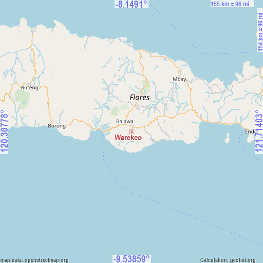
Warekeo GPS coordinates[2]
8° 50' 40.2" South, 121° 0' 39.24" East
| Map corner | latitude | longitude |
|---|---|---|
| Upper-left | -8.1491°, | 120.30778° |
| Center: | -8.8445°, | 121.0109° |
| Lower-right: | -9.53859°, | 121.71403° |
| Map W x H: | 154.5×154.5 km | = 96×96mi |
| max Lat: | 5.88969° ⇑92% North |
| Warekeo: | -8.8445° |
| min Lat: | ⇓8% South -10.934° |
| min Long | Warekeo | max Long |
| 95.1345° | 121.0109° | 140.9419° |
| W 85.6%⇐ | ⇒14.4% E |
Elevation
Elevation of Warekeo is 1291 m = 4236 ft, and this is 1061.3 m = 3482 ft above average elevation for this country.
| Max E: |
3185 m = 10449 ft | 0.59999999999999% |
| Warekeo | 1291 m 4236 ft | |
| Avg. | 229.7 m = 754 ft | |
Min E: |
-1 m = -3 ft | 99.4% |
See also: Indonesia elevation on elevation.city.
Geographical zone
Warekeo is located in South Torrid zone (between Equator and Tropic of Capricorn). Distance of Equator is 983.4 km =611.1 mi to North.| Distance of | km | miles | from Warekeo |
|---|---|---|---|
| Equator | 983.4 | 611.1 | to North |
| Tropic Capricorn | 1622.5 | 1008.2 | to South |
| Antarctic Circle | 6417.8 | 3987.8 | to South |
| South Pole | 9023.6 | 5607 | to South |


Nearby cities:
15 places around Warekeo: (largest is in red/bold)
• Bojawa
5.8 km =3.6 mi,  281°
281°
• Bosiko
4.4 km =2.7 mi,  329°
329°
• Doka
4.9 km =3 mi,  98°
98°
• Dorupare
5.2 km =3.2 mi,  62°
62°
• Gisiliba
4.8 km =3 mi,  72°
72°
• Gurusina
6.2 km =3.9 mi,  201°
201°
• Jadho
4.4 km =2.7 mi,  87°
87°
• Malabhaga
4.4 km =2.7 mi,  187°
187°
• Mangulewa
2.9 km =1.8 mi,  16°
16°
• Mari
5.7 km =3.5 mi,  289°
289°
• Mataloko
6.3 km =3.9 mi, 65°
• Nuamuzi
1.4 km =0.9 mi,  174°
174°
• Ranisoba
2.6 km =1.6 mi, 21°
• Sobo
2.6 km =1.6 mi,  28°
28°
• Were
6.2 km =3.9 mi,  119°
119°
Sources, notices
• [Note1] Compared only with cities in Indonesia existing in our database
• [Src1] Map data: © OpenStreetMap contributors (CC-BY-SA)
• [Src2] Other city data from geonames.org with taken over terms of usage.
• [Src3] Geographical zone / Annual Mean Temperature by Robert A. Rohde @ Wikipedia
