Waturoka geodata
Waturoka (East Nusa Tenggara) is a seat of a fourth-order administrative division; located in Indonesia in Asia/Makassar (GMT+8) time zone. In our database, there are 407 cities with bigger population. Compared to other cities in Indonesia, 92.3% of cities are located further ↑North; 85.8% of cities are located further ←West and 92.7% of cities have lower elevation than Waturoka. Note1


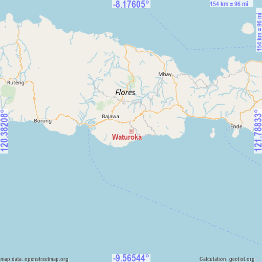
Waturoka GPS coordinates[2]
8° 52' 17.04" South, 121° 5' 6.72" East
| Map corner | latitude | longitude |
|---|---|---|
| Upper-left | -8.17605°, | 120.38208° |
| Center: | -8.8714°, | 121.0852° |
| Lower-right: | -9.56544°, | 121.78833° |
| Map W x H: | 154.5×154.5 km | = 96×96mi |
| max Lat: | 5.88969° ⇑92.3% North |
| Waturoka: | -8.8714° |
| min Lat: | ⇓7.7% South -10.934° |
| min Long | Waturoka | max Long |
| 95.1345° | 121.0852° | 140.9419° |
| W 85.8%⇐ | ⇒14.2% E |
Elevation
Elevation of Waturoka is 727 m = 2385 ft, and this is 497.3 m = 1632 ft above average elevation for this country.
| Max E: |
3185 m = 10449 ft | 7.3% |
| Waturoka | 727 m 2385 ft | |
| Avg. | 229.7 m = 754 ft | |
Min E: |
-1 m = -3 ft | 92.7% |
See also: Indonesia elevation on elevation.city.
Geographical zone
Waturoka is located in South Torrid zone (between Equator and Tropic of Capricorn). Distance of Equator is 986.4 km =612.9 mi to North.| Distance of | km | miles | from Waturoka |
|---|---|---|---|
| Equator | 986.4 | 612.9 | to North |
| Tropic Capricorn | 1619.5 | 1006.3 | to South |
| Antarctic Circle | 6414.8 | 3986 | to South |
| South Pole | 9020.7 | 5605.2 | to South |


Nearby cities:
15 places around Waturoka: (largest is in red/bold)
• Batawa
7.4 km =4.6 mi,  111°
111°
• Doka
4.1 km =2.5 mi,  304°
304°
• Dona
7.3 km =4.5 mi,  243°
243°
• Dorupare
6.4 km =4 mi,  326°
326°
• Gisiliba
5.7 km =3.5 mi,  321°
321°
• Jadho
4.9 km =3 mi,  310°
310°
• Laja
2.7 km =1.7 mi,  45°
45°
• Mataloko
6.2 km =3.9 mi,  336°
336°
• Maumbawa
6.4 km =4 mi,  117°
117°
• Ngedhubasa
8.6 km =5.3 mi,  199°
199°
• Nuamuzi
8.2 km =5.1 mi,  281°
281°
• Pogo
8.7 km =5.4 mi,  17°
17°
• Taka
4.7 km =2.9 mi,  42°
42°
• Wagha
8.1 km =5 mi,  87°
87°
• Were
2.7 km =1.7 mi,  267°
267°
Sources, notices
• [Note1] Compared only with cities in Indonesia existing in our database
• [Src1] Map data: © OpenStreetMap contributors (CC-BY-SA)
• [Src2] Other city data from geonames.org with taken over terms of usage.
• [Src3] Geographical zone / Annual Mean Temperature by Robert A. Rohde @ Wikipedia
