Taka geodata
Taka (East Nusa Tenggara) is a seat of a fourth-order administrative division; located in Indonesia in Asia/Makassar (GMT+8) time zone. In our database, there are 407 cities with bigger population. Compared to other cities in Indonesia, 92% of cities are located further ↑North; 85.9% of cities are located further ←West and 94.1% of cities have lower elevation than Taka. Note1


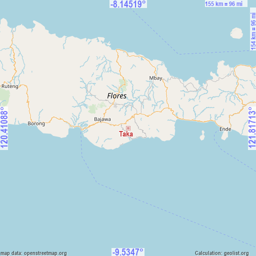
Taka GPS coordinates[2]
8° 50' 26.16" South, 121° 6' 50.4" East
| Map corner | latitude | longitude |
|---|---|---|
| Upper-left | -8.14519°, | 120.41088° |
| Center: | -8.8406°, | 121.114° |
| Lower-right: | -9.5347°, | 121.81713° |
| Map W x H: | 154.5×154.5 km | = 96×96mi |
| max Lat: | 5.88969° ⇑92% North |
| Taka: | -8.8406° |
| min Lat: | ⇓8% South -10.934° |
| min Long | Taka | max Long |
| 95.1345° | 121.114° | 140.9419° |
| W 85.9%⇐ | ⇒14.1% E |
Elevation
Elevation of Taka is 771 m = 2530 ft, and this is 541.3 m = 1776 ft above average elevation for this country.
| Max E: |
3185 m = 10449 ft | 5.9% |
| Taka | 771 m 2530 ft | |
| Avg. | 229.7 m = 754 ft | |
Min E: |
-1 m = -3 ft | 94.1% |
See also: Indonesia elevation on elevation.city.
Geographical zone
Taka is located in South Torrid zone (between Equator and Tropic of Capricorn). Distance of Equator is 983 km =610.8 mi to North.| Distance of | km | miles | from Taka |
|---|---|---|---|
| Equator | 983 | 610.8 | to North |
| Tropic Capricorn | 1622.9 | 1008.4 | to South |
| Antarctic Circle | 6418.2 | 3988.1 | to South |
| South Pole | 9024.1 | 5607.3 | to South |


Nearby cities:
15 places around Taka: (largest is in red/bold)
• Batawa
7.2 km =4.5 mi,  148°
148°
• Doka
6.6 km =4.1 mi,  260°
260°
• Dorupare
7 km =4.3 mi,  286°
286°
• Doya
5.7 km =3.5 mi,  70°
70°
• Gisiliba
6.8 km =4.2 mi,  278°
278°
• Hobonio
6.1 km =3.8 mi,  12°
12°
• Jadho
6.9 km =4.3 mi,  267°
267°
• Laja
2 km =1.2 mi,  218°
218°
• Mataloko
6 km =3.7 mi, 291°
• Maumbawa
6.9 km =4.3 mi,  158°
158°
• Nunukae
6.1 km =3.8 mi,  44°
44°
• Pogo
5 km =3.1 mi,  353°
353°
• Wagha
5.8 km =3.6 mi,  121°
121°
• Waturoka
4.7 km =2.9 mi, 222°
• Were
6.9 km =4.3 mi,  239°
239°
Sources, notices
• [Note1] Compared only with cities in Indonesia existing in our database
• [Src1] Map data: © OpenStreetMap contributors (CC-BY-SA)
• [Src2] Other city data from geonames.org with taken over terms of usage.
• [Src3] Geographical zone / Annual Mean Temperature by Robert A. Rohde @ Wikipedia
