Kedungdoro geodata
Kedungdoro (East Java) is a seat of a fourth-order administrative division; located in Indonesia in Asia/Jakarta (GMT+7) time zone. In our database, there are 407 cities with bigger population. Compared to other cities in Indonesia, 63.7% of cities are located further ↑North; 50.7% of cities are located further →East and 51.1% of cities have higher elevation than Kedungdoro. Note1


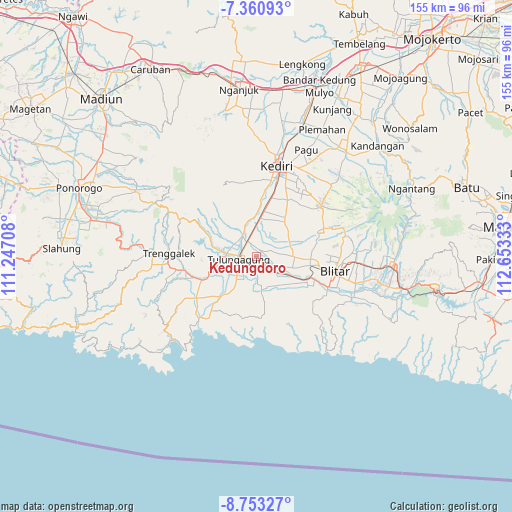
Kedungdoro GPS coordinates[2]
8° 3' 27.72" South, 111° 57' 0.72" East
| Map corner | latitude | longitude |
|---|---|---|
| Upper-left | -7.36093°, | 111.24708° |
| Center: | -8.0577°, | 111.9502° |
| Lower-right: | -8.75327°, | 112.65333° |
| Map W x H: | 154.8×154.8 km | = 96.2×96.2mi |
| max Lat: | 5.88969° ⇑63.7% North |
| Kedungdoro: | -8.0577° |
| min Lat: | ⇓36.3% South -10.934° |
| min Long | Kedungdoro | max Long |
| 95.1345° | 111.9502° | 140.9419° |
| W 49.3%⇐ | ⇒50.7% E |
Elevation
Elevation of Kedungdoro is 98 m = 322 ft, and this is 131.7 m = 432 ft below average elevation for this country.
| Max E: |
3185 m = 10449 ft | 51.1% |
| Avg. | 229.7 m = 754 ft | |
| Kedungdoro | 98 m = 322 ft | |
Min E: |
-1 m = -3 ft | 48.9% |
See also: Indonesia elevation on elevation.city.
Geographical zone
Kedungdoro is located in South Torrid zone (between Equator and Tropic of Capricorn). Distance of Equator is 895.9 km =556.7 mi to North.| Distance of | km | miles | from Kedungdoro |
|---|---|---|---|
| Equator | 895.9 | 556.7 | to North |
| Tropic Capricorn | 1710 | 1062.5 | to South |
| Antarctic Circle | 6505.2 | 4042.1 | to South |
| South Pole | 9111.1 | 5661.4 | to South |


Nearby cities:
15 places around Kedungdoro: (largest is in red/bold)
• Balong
3 km =1.9 mi,  15°
15°
• Bangoan
1.8 km =1.1 mi,  325°
325°
• Bulusari
0.8 km =0.5 mi,  358°
358°
• Jabalan
3.3 km =2.1 mi,  146°
146°
• Jati
0.9 km =0.6 mi,  79°
79°
• Kaliboto
3.7 km =2.3 mi,  63°
63°
• Kudusan
3.5 km =2.2 mi,  228°
228°
• Mayangan
2.2 km =1.4 mi, 17°
• Mekarsari
3 km =1.9 mi,  254°
254°
• Pucung
2.6 km =1.6 mi, 78°
• Ringinagung
2 km =1.2 mi,  260°
260°
• Sadar
3.7 km =2.3 mi,  176°
176°
• Sambirobyong
2.3 km =1.4 mi,  110°
110°
• Selojeneng
2.3 km =1.4 mi,  189°
189°
• Tapan
3.5 km =2.2 mi,  321°
321°
Sources, notices
• [Note1] Compared only with cities in Indonesia existing in our database
• [Src1] Map data: © OpenStreetMap contributors (CC-BY-SA)
• [Src2] Other city data from geonames.org with taken over terms of usage.
• [Src3] Geographical zone / Annual Mean Temperature by Robert A. Rohde @ Wikipedia
