Bendilwungu Lor geodata
Bendilwungu Lor (East Java) is a seat of a fourth-order administrative division; located in Indonesia in Asia/Jakarta (GMT+7) time zone. In our database, there are 407 cities with bigger population. Compared to other cities in Indonesia, 66.7% of cities are located further ↑North; 50.7% of cities are located further →East and 51.4% of cities have higher elevation than Bendilwungu Lor. Note1


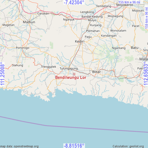
Bendilwungu Lor GPS coordinates[2]
8° 7' 10.92" South, 111° 57' 11.52" East
| Map corner | latitude | longitude |
|---|---|---|
| Upper-left | -7.42304°, | 111.25008° |
| Center: | -8.1197°, | 111.9532° |
| Lower-right: | -8.81516°, | 112.65633° |
| Map W x H: | 154.8×154.8 km | = 96.2×96.2mi |
| max Lat: | 5.88969° ⇑66.7% North |
| Bendilwungu Lor: | -8.1197° |
| min Lat: | ⇓33.3% South -10.934° |
| min Long | Bendilwungu Lor | max Long |
| 95.1345° | 111.9532° | 140.9419° |
| W 49.3%⇐ | ⇒50.7% E |
Elevation
Elevation of Bendilwungu Lor is 97 m = 318 ft, and this is 132.7 m = 435 ft below average elevation for this country.
| Max E: |
3185 m = 10449 ft | 51.4% |
| Avg. | 229.7 m = 754 ft | |
| Bendilwungu Lor | 97 m = 318 ft | |
Min E: |
-1 m = -3 ft | 48.6% |
See also: Indonesia elevation on elevation.city.
Geographical zone
Bendilwungu Lor is located in South Torrid zone (between Equator and Tropic of Capricorn). Distance of Equator is 902.8 km =561 mi to North.| Distance of | km | miles | from Bendilwungu Lor |
|---|---|---|---|
| Equator | 902.8 | 561 | to North |
| Tropic Capricorn | 1703.1 | 1058.3 | to South |
| Antarctic Circle | 6498.3 | 4037.9 | to South |
| South Pole | 9104.2 | 5657.1 | to South |


Nearby cities:
15 places around Bendilwungu Lor: (largest is in red/bold)
• Bendilmuning
3.3 km =2.1 mi,  337°
337°
• Brandil
2.9 km =1.8 mi,  173°
173°
• Cangkringan
1.9 km =1.2 mi,  90°
90°
• Dawuhan
0.9 km =0.6 mi,  317°
317°
• Doropayung
2 km =1.2 mi, 315°
• Dukuh
2.8 km =1.7 mi,  65°
65°
• Mirigambar
3.4 km =2.1 mi,  117°
117°
• Pandansari
3.3 km =2.1 mi,  103°
103°
• Sadar
3.2 km =2 mi,  358°
358°
• Sadeng
2 km =1.2 mi,  46°
46°
• Sambidoplang
2.5 km =1.6 mi,  143°
143°
• Sambirejo
2.9 km =1.8 mi,  186°
186°
• Setonokalong
3.1 km =1.9 mi,  20°
20°
• Tambaksumber
1.7 km =1.1 mi,  354°
354°
• Wates
1.4 km =0.9 mi,  176°
176°
Sources, notices
• [Note1] Compared only with cities in Indonesia existing in our database
• [Src1] Map data: © OpenStreetMap contributors (CC-BY-SA)
• [Src2] Other city data from geonames.org with taken over terms of usage.
• [Src3] Geographical zone / Annual Mean Temperature by Robert A. Rohde @ Wikipedia
