Baroh geodata
Baroh (East Nusa Tenggara) is a seat of a fourth-order administrative division; located in Indonesia in Asia/Makassar (GMT+8) time zone. In our database, there are 407 cities with bigger population. Compared to other cities in Indonesia, 92.9% of cities are located further ↑North; 81% of cities are located further ←West and 52% of cities have higher elevation than Baroh. Note1


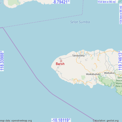
Baroh GPS coordinates[2]
9° 29' 18.24" South, 119° 2' 34.8" East
| Map corner | latitude | longitude |
|---|---|---|
| Upper-left | -8.79421°, | 118.33988° |
| Center: | -9.4884°, | 119.043° |
| Lower-right: | -10.18119°, | 119.74613° |
| Map W x H: | 154.2×154.2 km | = 95.8×95.8mi |
| max Lat: | 5.88969° ⇑92.9% North |
| Baroh: | -9.4884° |
| min Lat: | ⇓7.1% South -10.934° |
| min Long | Baroh | max Long |
| 95.1345° | 119.043° | 140.9419° |
| W 81%⇐ | ⇒19% E |
Elevation
Elevation of Baroh is 95 m = 312 ft, and this is 134.7 m = 442 ft below average elevation for this country.
| Max E: |
3185 m = 10449 ft | 52% |
| Avg. | 229.7 m = 754 ft | |
| Baroh | 95 m = 312 ft | |
Min E: |
-1 m = -3 ft | 48% |
See also: Indonesia elevation on elevation.city.
Geographical zone
Baroh is located in South Torrid zone (between Equator and Tropic of Capricorn). Distance of Equator is 1055 km =655.5 mi to North.| Distance of | km | miles | from Baroh |
|---|---|---|---|
| Equator | 1055 | 655.5 | to North |
| Tropic Capricorn | 1550.9 | 963.7 | to South |
| Antarctic Circle | 6346.2 | 3943.3 | to South |
| South Pole | 8952.1 | 5562.6 | to South |


Nearby cities:
15 places around Baroh: (largest is in red/bold)
• Batang
13.1 km =8.1 mi,  207°
207°
• Bondokodi
13 km =8.1 mi,  204°
204°
• Dinjo
12.2 km =7.6 mi, 195°
• Hamonggolele
11.5 km =7.1 mi, 207°
• Hohawungo
5.3 km =3.3 mi, 203°
• Hombakaripit
3.8 km =2.4 mi, 197°
• Kaloghodalo
9 km =5.6 mi,  223°
223°
• Kawangohari
7.3 km =4.5 mi, 216°
• Kori
2.4 km =1.5 mi, 202°
• Lokorota
11.3 km =7 mi,  167°
167°
• Maliiha
7.6 km =4.7 mi, 199°
• Padedemanu
7.8 km =4.8 mi,  57°
57°
• Waiholo
5.6 km =3.5 mi,  125°
125°
• Weekombaka
11.1 km =6.9 mi,  102°
102°
• Weetombo
12.7 km =7.9 mi, 132°
Sources, notices
• [Note1] Compared only with cities in Indonesia existing in our database
• [Src1] Map data: © OpenStreetMap contributors (CC-BY-SA)
• [Src2] Other city data from geonames.org with taken over terms of usage.
• [Src3] Geographical zone / Annual Mean Temperature by Robert A. Rohde @ Wikipedia
