Kaloghodalo geodata
Kaloghodalo (East Nusa Tenggara) is a seat of a fourth-order administrative division; located in Indonesia in Asia/Makassar (GMT+8) time zone. In our database, there are 407 cities with bigger population. Compared to other cities in Indonesia, 93.3% of cities are located further ↑North; 80.7% of cities are located further ←West and 52% of cities have higher elevation than Kaloghodalo. Note1


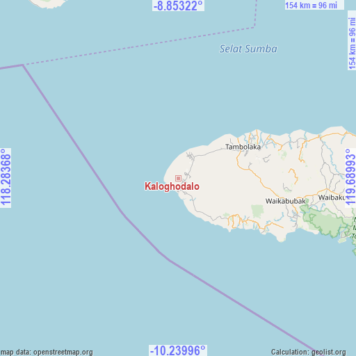
Kaloghodalo GPS coordinates[2]
9° 32' 50.28" South, 118° 59' 12.48" East
| Map corner | latitude | longitude |
|---|---|---|
| Upper-left | -8.85322°, | 118.28368° |
| Center: | -9.5473°, | 118.9868° |
| Lower-right: | -10.23996°, | 119.68993° |
| Map W x H: | 154.2×154.2 km | = 95.8×95.8mi |
| max Lat: | 5.88969° ⇑93.3% North |
| Kaloghodalo: | -9.5473° |
| min Lat: | ⇓6.7% South -10.934° |
| min Long | Kaloghodalo | max Long |
| 95.1345° | 118.9868° | 140.9419° |
| W 80.7%⇐ | ⇒19.3% E |
Elevation
Elevation of Kaloghodalo is 95 m = 312 ft, and this is 134.7 m = 442 ft below average elevation for this country.
| Max E: |
3185 m = 10449 ft | 52% |
| Avg. | 229.7 m = 754 ft | |
| Kaloghodalo | 95 m = 312 ft | |
Min E: |
-1 m = -3 ft | 48% |
See also: Indonesia elevation on elevation.city.
Geographical zone
Kaloghodalo is located in South Torrid zone (between Equator and Tropic of Capricorn). Distance of Equator is 1061.6 km =659.6 mi to North.| Distance of | km | miles | from Kaloghodalo |
|---|---|---|---|
| Equator | 1061.6 | 659.6 | to North |
| Tropic Capricorn | 1544.4 | 959.6 | to South |
| Antarctic Circle | 6339.6 | 3939.2 | to South |
| South Pole | 8945.5 | 5558.5 | to South |


Nearby cities:
15 places around Kaloghodalo: (largest is in red/bold)
• Baroh
9 km =5.6 mi,  43°
43°
• Batang
5 km =3.1 mi,  179°
179°
• Bondokodi
5.3 km =3.3 mi,  172°
172°
• Bonggor
5.3 km =3.3 mi,  255°
255°
• Dinjo
6 km =3.7 mi,  150°
150°
• Hamonggolele
3.8 km =2.4 mi, 166°
• Hohawungo
4.4 km =2.7 mi,  67°
67°
• Hombakaripit
5.8 km =3.6 mi,  60°
60°
• Kawangohari
1.9 km =1.2 mi, 68°
• Kori
6.8 km =4.2 mi,  50°
50°
• Leteloko
7.3 km =4.5 mi, 151°
• Lokorota
9.7 km =6 mi,  117°
117°
• Maliiha
3.6 km =2.2 mi,  99°
99°
• Waiha
11.6 km =7.2 mi, 147°
• Waiholo
11.2 km =7 mi, 73°
Sources, notices
• [Note1] Compared only with cities in Indonesia existing in our database
• [Src1] Map data: © OpenStreetMap contributors (CC-BY-SA)
• [Src2] Other city data from geonames.org with taken over terms of usage.
• [Src3] Geographical zone / Annual Mean Temperature by Robert A. Rohde @ Wikipedia
