Rate geodata
Rate (West Nusa Tenggara) is a seat of a fourth-order administrative division; located in Indonesia in Asia/Makassar (GMT+8) time zone. In our database, there are 407 cities with bigger population. Compared to other cities in Indonesia, 84.9% of cities are located further ↑North; 79.8% of cities are located further ←West and 62.1% of cities have higher elevation than Rate. Note1


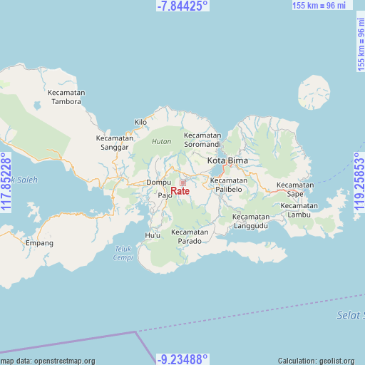
Rate GPS coordinates[2]
8° 32' 24.72" South, 118° 33' 19.44" East
| Map corner | latitude | longitude |
|---|---|---|
| Upper-left | -7.84425°, | 117.85228° |
| Center: | -8.5402°, | 118.5554° |
| Lower-right: | -9.23488°, | 119.25853° |
| Map W x H: | 154.6×154.6 km | = 96.1×96.1mi |
| max Lat: | 5.88969° ⇑84.9% North |
| Rate: | -8.5402° |
| min Lat: | ⇓15.1% South -10.934° |
| min Long | Rate | max Long |
| 95.1345° | 118.5554° | 140.9419° |
| W 79.8%⇐ | ⇒20.2% E |
Elevation
Elevation of Rate is 51 m = 167 ft, and this is 178.7 m = 586 ft below average elevation for this country.
| Max E: |
3185 m = 10449 ft | 62.1% |
| Avg. | 229.7 m = 754 ft | |
| Rate | 51 m = 167 ft | |
Min E: |
-1 m = -3 ft | 37.9% |
See also: Indonesia elevation on elevation.city.
Geographical zone
Rate is located in South Torrid zone (between Equator and Tropic of Capricorn). Distance of Equator is 949.6 km =590.1 mi to North.| Distance of | km | miles | from Rate |
|---|---|---|---|
| Equator | 949.6 | 590.1 | to North |
| Tropic Capricorn | 1656.3 | 1029.2 | to South |
| Antarctic Circle | 6451.6 | 4008.8 | to South |
| South Pole | 9057.5 | 5628.1 | to South |


Nearby cities:
15 places around Rate: (largest is in red/bold)
• Beringin
2.6 km =1.6 mi,  45°
45°
• Campa
5.8 km =3.6 mi,  151°
151°
• Dompu
10.1 km =6.3 mi,  272°
272°
• Leu
8.5 km =5.3 mi,  63°
63°
• Melati
8.3 km =5.2 mi, 63°
• Monggo
3.2 km =2 mi,  23°
23°
• Ndano
5.2 km =3.2 mi,  341°
341°
• Palama
7.6 km =4.7 mi, 344°
• Rato
8.2 km =5.1 mi, 62°
• Rora
8.5 km =5.3 mi,  325°
325°
• Rora Timur
10.1 km =6.3 mi,  306°
306°
• Sila
8.2 km =5.1 mi, 59°
• Tambe
6.4 km =4 mi, 58°
• Tolomango
7.5 km =4.7 mi, 58°
• Woro
3.9 km =2.4 mi,  199°
199°
Sources, notices
• [Note1] Compared only with cities in Indonesia existing in our database
• [Src1] Map data: © OpenStreetMap contributors (CC-BY-SA)
• [Src2] Other city data from geonames.org with taken over terms of usage.
• [Src3] Geographical zone / Annual Mean Temperature by Robert A. Rohde @ Wikipedia
