Rato geodata
Rato (West Nusa Tenggara) is a seat of a fourth-order administrative division; located in Indonesia in Asia/Makassar (GMT+8) time zone. In our database, there are 407 cities with bigger population. Compared to other cities in Indonesia, 83.6% of cities are located further ↑North; 79.9% of cities are located further ←West and 77.1% of cities have higher elevation than Rato. Note1


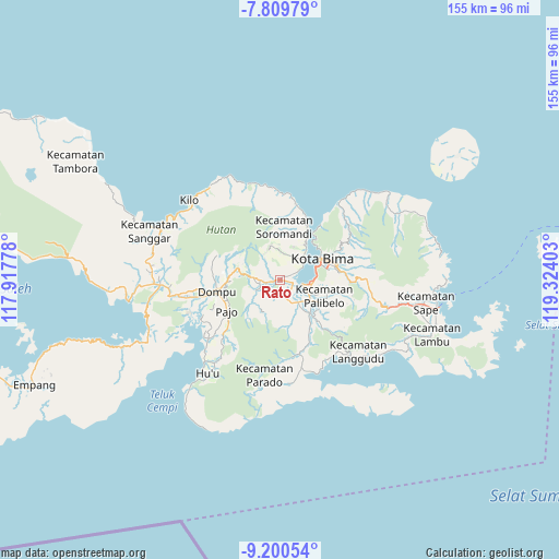
Rato GPS coordinates[2]
8° 30' 20.88" South, 118° 37' 15.24" East
| Map corner | latitude | longitude |
|---|---|---|
| Upper-left | -7.80979°, | 117.91778° |
| Center: | -8.5058°, | 118.6209° |
| Lower-right: | -9.20054°, | 119.32403° |
| Map W x H: | 154.6×154.6 km | = 96.1×96.1mi |
| max Lat: | 5.88969° ⇑83.6% North |
| Rato: | -8.5058° |
| min Lat: | ⇓16.4% South -10.934° |
| min Long | Rato | max Long |
| 95.1345° | 118.6209° | 140.9419° |
| W 79.9%⇐ | ⇒20.1% E |
Elevation
Elevation of Rato is 22 m = 72 ft, and this is 207.7 m = 681 ft below average elevation for this country.
| Max E: |
3185 m = 10449 ft | 77.1% |
| Avg. | 229.7 m = 754 ft | |
| Rato | 22 m = 72 ft | |
Min E: |
-1 m = -3 ft | 22.9% |
See also: Indonesia elevation on elevation.city.
Geographical zone
Rato is located in South Torrid zone (between Equator and Tropic of Capricorn). Distance of Equator is 945.8 km =587.7 mi to North.| Distance of | km | miles | from Rato |
|---|---|---|---|
| Equator | 945.8 | 587.7 | to North |
| Tropic Capricorn | 1660.2 | 1031.6 | to South |
| Antarctic Circle | 6455.4 | 4011.2 | to South |
| South Pole | 9061.3 | 5630.4 | to South |


Nearby cities:
15 places around Rato: (largest is in red/bold)
• Beringin
5.7 km =3.5 mi,  249°
249°
• Donggo
9.5 km =5.9 mi,  342°
342°
• Godo
7.9 km =4.9 mi,  140°
140°
• Leu
0.4 km =0.2 mi,  102°
102°
• Manggenae
8.4 km =5.2 mi,  357°
357°
• Melati
0.3 km =0.2 mi,  119°
119°
• Monggo
6 km =3.7 mi,  261°
261°
• Ndano
8.9 km =5.5 mi,  277°
277°
• Oo
9.7 km =6 mi, 344°
• Palama
9.8 km =6.1 mi,  290°
290°
• Rate
8.2 km =5.1 mi,  242°
242°
• Sangari
8.5 km =5.3 mi,  327°
327°
• Sila
0.4 km =0.2 mi, 344°
• Tambe
1.8 km =1.1 mi, 255°
• Tolomango
0.8 km =0.5 mi,  274°
274°
Sources, notices
• [Note1] Compared only with cities in Indonesia existing in our database
• [Src1] Map data: © OpenStreetMap contributors (CC-BY-SA)
• [Src2] Other city data from geonames.org with taken over terms of usage.
• [Src3] Geographical zone / Annual Mean Temperature by Robert A. Rohde @ Wikipedia
