Walakeri geodata
Walakeri (East Nusa Tenggara) is a seat of a fourth-order administrative division; located in Indonesia in Asia/Makassar (GMT+8) time zone. In our database, there are 407 cities with bigger population. Compared to other cities in Indonesia, 98.1% of cities are located further ↑North; 84.4% of cities are located further ←West and 80.9% of cities have higher elevation than Walakeri. Note1


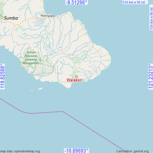
Walakeri GPS coordinates[2]
10° 12' 20.52" South, 120° 31' 44.4" East
| Map corner | latitude | longitude |
|---|---|---|
| Upper-left | -9.51296°, | 119.82588° |
| Center: | -10.2057°, | 120.529° |
| Lower-right: | -10.89693°, | 121.23213° |
| Map W x H: | 153.9×153.9 km | = 95.6×95.6mi |
| max Lat: | 5.88969° ⇑98.1% North |
| Walakeri: | -10.2057° |
| min Lat: | ⇓1.9% South -10.934° |
| min Long | Walakeri | max Long |
| 95.1345° | 120.529° | 140.9419° |
| W 84.4%⇐ | ⇒15.6% E |
Elevation
Elevation of Walakeri is 18 m = 59 ft, and this is 211.7 m = 695 ft below average elevation for this country.
| Max E: |
3185 m = 10449 ft | 80.9% |
| Avg. | 229.7 m = 754 ft | |
| Walakeri | 18 m = 59 ft | |
Min E: |
-1 m = -3 ft | 19.1% |
See also: Indonesia elevation on elevation.city.
Geographical zone
Walakeri is located in South Torrid zone (between Equator and Tropic of Capricorn). Distance of Equator is 1134.8 km =705.1 mi to North.| Distance of | km | miles | from Walakeri |
|---|---|---|---|
| Equator | 1134.8 | 705.1 | to North |
| Tropic Capricorn | 1471.2 | 914.2 | to South |
| Antarctic Circle | 6266.4 | 3893.8 | to South |
| South Pole | 8872.3 | 5513 | to South |


Nearby cities:
15 places around Walakeri: (largest is in red/bold)
• Baing
3.7 km =2.3 mi,  117°
117°
• Kalangga
24.1 km =15 mi,  282°
282°
• Kaliuda
20.8 km =12.9 mi,  77°
77°
• Latang
20.2 km =12.6 mi,  306°
306°
• Maradabangga
18.8 km =11.7 mi, 279°
• Maumaru
22.7 km =14.1 mi,  351°
351°
• Mbulung
2.4 km =1.5 mi,  149°
149°
• Ngalu
20.8 km =12.9 mi,  71°
71°
• Nggai
19.3 km =12 mi,  269°
269°
• Pahenya
0.6 km =0.4 mi, 82°
• Panjir
24.1 km =15 mi,  326°
326°
• Ratilangi
21.9 km =13.6 mi, 71°
• Tangguhang
12.3 km =7.6 mi,  61°
61°
• Umakadambung
3.5 km =2.2 mi,  104°
104°
• Umanggudang
17.6 km =10.9 mi,  343°
343°
Sources, notices
• [Note1] Compared only with cities in Indonesia existing in our database
• [Src1] Map data: © OpenStreetMap contributors (CC-BY-SA)
• [Src2] Other city data from geonames.org with taken over terms of usage.
• [Src3] Geographical zone / Annual Mean Temperature by Robert A. Rohde @ Wikipedia
