Montor Timur geodata
Montor Timur (Banten) is a seat of a fourth-order administrative division; located in Indonesia in Asia/Jakarta (GMT+7) time zone. In our database, there are 407 cities with bigger population. Compared to other cities in Indonesia, 85.4% of cities are located further ↓South; 92.8% of cities are located further →East and 62.8% of cities have higher elevation than Montor Timur. Note1


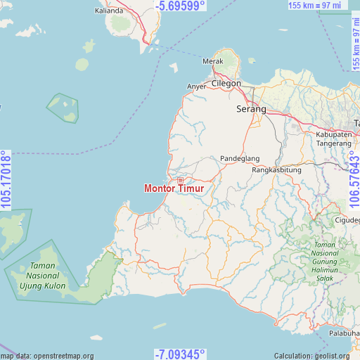
Montor Timur GPS coordinates[2]
6° 23' 42.72" South, 105° 52' 23.88" East
| Map corner | latitude | longitude |
|---|---|---|
| Upper-left | -5.69599°, | 105.17018° |
| Center: | -6.3952°, | 105.8733° |
| Lower-right: | -7.09345°, | 106.57643° |
| Map W x H: | 155.4×155.4 km | = 96.6×96.6mi |
| max Lat: | 5.88969° ⇑14.6% North |
| Montor Timur: | -6.3952° |
| min Lat: | ⇓85.4% South -10.934° |
| min Long | Montor Timur | max Long |
| 95.1345° | 105.8733° | 140.9419° |
| W 7.2%⇐ | ⇒92.8% E |
Elevation
Elevation of Montor Timur is 49 m = 161 ft, and this is 180.7 m = 593 ft below average elevation for this country.
| Max E: |
3185 m = 10449 ft | 62.8% |
| Avg. | 229.7 m = 754 ft | |
| Montor Timur | 49 m = 161 ft | |
Min E: |
-1 m = -3 ft | 37.2% |
See also: Indonesia elevation on elevation.city.
Geographical zone
Montor Timur is located in South Torrid zone (between Equator and Tropic of Capricorn). Distance of Equator is 711.1 km =441.9 mi to North.| Distance of | km | miles | from Montor Timur |
|---|---|---|---|
| Equator | 711.1 | 441.9 | to North |
| Tropic Capricorn | 1894.8 | 1177.4 | to South |
| Antarctic Circle | 6690.1 | 4157 | to South |
| South Pole | 9296 | 5776.3 | to South |


Nearby cities:
15 places around Montor Timur: (largest is in red/bold)
• Badur
3.3 km =2.1 mi,  299°
299°
• Bangko Dua
1.7 km =1.1 mi,  52°
52°
• Cirumput
1.2 km =0.7 mi,  98°
98°
• Gonggong
2.8 km =1.7 mi,  72°
72°
• Jami
3.2 km =2 mi,  18°
18°
• Kadubadak
0.5 km =0.3 mi,  329°
329°
• Kadugadung
1.9 km =1.2 mi,  278°
278°
• Kadupayung
2.8 km =1.7 mi,  266°
266°
• Kapinango
2.3 km =1.4 mi,  211°
211°
• Kubang
2.9 km =1.8 mi,  158°
158°
• Kuluwut Tengah
2.4 km =1.5 mi,  148°
148°
• Padahayu
2.9 km =1.8 mi, 331°
• Pangampoan
2.4 km =1.5 mi,  260°
260°
• Parigi
1.5 km =0.9 mi,  9°
9°
• Tegal
2.8 km =1.7 mi,  111°
111°
Sources, notices
• [Note1] Compared only with cities in Indonesia existing in our database
• [Src1] Map data: © OpenStreetMap contributors (CC-BY-SA)
• [Src2] Other city data from geonames.org with taken over terms of usage.
• [Src3] Geographical zone / Annual Mean Temperature by Robert A. Rohde @ Wikipedia
