Gonggong geodata
Gonggong (Banten) is a seat of a fourth-order administrative division; located in Indonesia in Asia/Jakarta (GMT+7) time zone. In our database, there are 407 cities with bigger population. Compared to other cities in Indonesia, 85.5% of cities are located further ↓South; 92.5% of cities are located further →East and 56.8% of cities have higher elevation than Gonggong. Note1


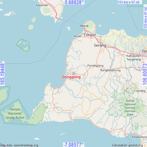
Gonggong GPS coordinates[2]
6° 23' 15" South, 105° 53' 51.36" East
| Map corner | latitude | longitude |
|---|---|---|
| Upper-left | -5.68828°, | 105.19448° |
| Center: | -6.3875°, | 105.8976° |
| Lower-right: | -7.08577°, | 106.60073° |
| Map W x H: | 155.4×155.4 km | = 96.6×96.6mi |
| max Lat: | 5.88969° ⇑14.5% North |
| Gonggong: | -6.3875° |
| min Lat: | ⇓85.5% South -10.934° |
| min Long | Gonggong | max Long |
| 95.1345° | 105.8976° | 140.9419° |
| W 7.5%⇐ | ⇒92.5% E |
Elevation
Elevation of Gonggong is 74 m = 243 ft, and this is 155.7 m = 511 ft below average elevation for this country.
| Max E: |
3185 m = 10449 ft | 56.8% |
| Avg. | 229.7 m = 754 ft | |
| Gonggong | 74 m = 243 ft | |
Min E: |
-1 m = -3 ft | 43.2% |
See also: Indonesia elevation on elevation.city.
Geographical zone
Gonggong is located in South Torrid zone (between Equator and Tropic of Capricorn). Distance of Equator is 710.2 km =441.3 mi to North.| Distance of | km | miles | from Gonggong |
|---|---|---|---|
| Equator | 710.2 | 441.3 | to North |
| Tropic Capricorn | 1895.7 | 1177.9 | to South |
| Antarctic Circle | 6691 | 4157.6 | to South |
| South Pole | 9296.8 | 5776.8 | to South |


Nearby cities:
15 places around Gonggong: (largest is in red/bold)
• Bangko Dua
1.3 km =0.8 mi,  278°
278°
• Cikiray
1 km =0.6 mi,  20°
20°
• Cirumput
1.8 km =1.1 mi,  234°
234°
• Jami
2.7 km =1.7 mi,  322°
322°
• Kadubadak
3 km =1.9 mi,  262°
262°
• Kaducukang
2.3 km =1.4 mi,  104°
104°
• Kebonjeruk
2.7 km =1.7 mi,  93°
93°
• Kuluwut Tengah
3.2 km =2 mi,  206°
206°
• Leuweungkolot
3.5 km =2.2 mi, 99°
• Menes
2.7 km =1.7 mi,  60°
60°
• Montor Timur
2.8 km =1.7 mi,  252°
252°
• Muruy
2.4 km =1.5 mi,  6°
6°
• Parigi
2.5 km =1.6 mi, 284°
• Sorodot
3.3 km =2.1 mi,  30°
30°
• Tegal
1.9 km =1.2 mi,  181°
181°
Sources, notices
• [Note1] Compared only with cities in Indonesia existing in our database
• [Src1] Map data: © OpenStreetMap contributors (CC-BY-SA)
• [Src2] Other city data from geonames.org with taken over terms of usage.
• [Src3] Geographical zone / Annual Mean Temperature by Robert A. Rohde @ Wikipedia
