Legokkopra geodata
Legokkopra (Banten) is a seat of a fourth-order administrative division; located in Indonesia in Asia/Jakarta (GMT+7) time zone. In our database, there are 407 cities with bigger population. Compared to other cities in Indonesia, 85.3% of cities are located further ↓South; 91.6% of cities are located further →East and 51% of cities have lower elevation than Legokkopra. Note1


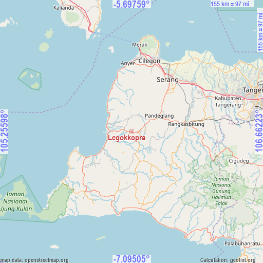
Legokkopra GPS coordinates[2]
6° 23' 48.48" South, 105° 57' 32.76" East
| Map corner | latitude | longitude |
|---|---|---|
| Upper-left | -5.69759°, | 105.25598° |
| Center: | -6.3968°, | 105.9591° |
| Lower-right: | -7.09505°, | 106.66223° |
| Map W x H: | 155.4×155.4 km | = 96.6×96.6mi |
| max Lat: | 5.88969° ⇑14.7% North |
| Legokkopra: | -6.3968° |
| min Lat: | ⇓85.3% South -10.934° |
| min Long | Legokkopra | max Long |
| 95.1345° | 105.9591° | 140.9419° |
| W 8.4%⇐ | ⇒91.6% E |
Elevation
Elevation of Legokkopra is 106 m = 348 ft, and this is 123.7 m = 406 ft below average elevation for this country.
| Max E: |
3185 m = 10449 ft | 49% |
| Avg. | 229.7 m = 754 ft | |
| Legokkopra | 106 m = 348 ft | |
Min E: |
-1 m = -3 ft | 51% |
See also: Indonesia elevation on elevation.city.
Geographical zone
Legokkopra is located in South Torrid zone (between Equator and Tropic of Capricorn). Distance of Equator is 711.3 km =442 mi to North.| Distance of | km | miles | from Legokkopra |
|---|---|---|---|
| Equator | 711.3 | 442 | to North |
| Tropic Capricorn | 1894.7 | 1177.3 | to South |
| Antarctic Circle | 6689.9 | 4156.9 | to South |
| South Pole | 9295.8 | 5776.1 | to South |


Nearby cities:
15 places around Legokkopra: (largest is in red/bold)
• Bongbong
1.1 km =0.7 mi,  284°
284°
• Ciherang
2.8 km =1.7 mi,  336°
336°
• Ganjur Girang
2.4 km =1.5 mi,  107°
107°
• Kadupinang
2.8 km =1.7 mi,  155°
155°
• Kaduronyok
2.6 km =1.6 mi,  3°
3°
• Kaduseeng
1.1 km =0.7 mi,  88°
88°
• Kampungmasjid
3.6 km =2.2 mi, 158°
• Langensari
3.4 km =2.1 mi,  213°
213°
• Leuweungkolot
3.4 km =2.1 mi, 278°
• Manungtung
2.7 km =1.7 mi,  318°
318°
• Pasirtundun
2.1 km =1.3 mi, 207°
• Pasirwaringin
2.4 km =1.5 mi,  234°
234°
• Saketi
3.7 km =2.3 mi,  97°
97°
• Sukamara
2.7 km =1.7 mi,  310°
310°
• Timbang
2.8 km =1.7 mi,  65°
65°
Sources, notices
• [Note1] Compared only with cities in Indonesia existing in our database
• [Src1] Map data: © OpenStreetMap contributors (CC-BY-SA)
• [Src2] Other city data from geonames.org with taken over terms of usage.
• [Src3] Geographical zone / Annual Mean Temperature by Robert A. Rohde @ Wikipedia
