Burujul geodata
Burujul (West Java) is a seat of a fourth-order administrative division; located in Indonesia in Asia/Jakarta (GMT+7) time zone. In our database, there are 407 cities with bigger population. Compared to other cities in Indonesia, 57.2% of cities are located further ↑North; 83.4% of cities are located further →East and 65.7% of cities have lower elevation than Burujul. Note1


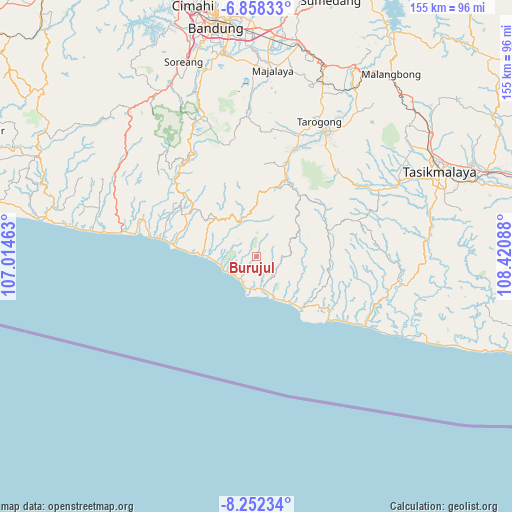
Burujul GPS coordinates[2]
7° 33' 21.24" South, 107° 43' 3.9" East
| Map corner | latitude | longitude |
|---|---|---|
| Upper-left | -6.85833°, | 107.01463° |
| Center: | -7.5559°, | 107.71775° |
| Lower-right: | -8.25234°, | 108.42088° |
| Map W x H: | 155×155 km | = 96.3×96.3mi |
| max Lat: | 5.88969° ⇑57.2% North |
| Burujul: | -7.5559° |
| min Lat: | ⇓42.8% South -10.934° |
| min Long | Burujul | max Long |
| 95.1345° | 107.71775° | 140.9419° |
| W 16.6%⇐ | ⇒83.4% E |
Elevation
Elevation of Burujul is 233 m = 764 ft, and this is 3.3 m = 11 ft above average elevation for this country.
| Max E: |
3185 m = 10449 ft | 34.3% |
| Burujul | 233 m 764 ft | |
| Avg. | 229.7 m = 754 ft | |
Min E: |
-1 m = -3 ft | 65.7% |
See also: Indonesia elevation on elevation.city.
Geographical zone
Burujul is located in South Torrid zone (between Equator and Tropic of Capricorn). Distance of Equator is 840.1 km =522 mi to North.| Distance of | km | miles | from Burujul |
|---|---|---|---|
| Equator | 840.1 | 522 | to North |
| Tropic Capricorn | 1765.8 | 1097.2 | to South |
| Antarctic Circle | 6561 | 4076.8 | to South |
| South Pole | 9166.9 | 5696 | to South |


Nearby cities:
15 places around Burujul: (largest is in red/bold)
• Babakan
8.9 km =5.5 mi,  184°
184°
• Bojong
4.9 km =3 mi,  156°
156°
• Cibitung
4.1 km =2.5 mi,  303°
303°
• Cigolewang
2.7 km =1.7 mi,  60°
60°
• Cijambe
7.9 km =4.9 mi,  217°
217°
• Cikalong
8.7 km =5.4 mi,  319°
319°
• Cikelet
7.7 km =4.8 mi, 215°
• Citeureup
8.5 km =5.3 mi,  187°
187°
• Datarpasang
6.8 km =4.2 mi,  118°
118°
• Gunungsulah
9.2 km =5.7 mi,  231°
231°
• Hegarmanah
8.9 km =5.5 mi,  93°
93°
• Margamulya
7.8 km =4.8 mi,  49°
49°
• Pangligaran
7.6 km =4.7 mi,  130°
130°
• Panyindangan
5 km =3.1 mi,  114°
114°
• Puncaksari
9.4 km =5.8 mi,  169°
169°
Sources, notices
• [Note1] Compared only with cities in Indonesia existing in our database
• [Src1] Map data: © OpenStreetMap contributors (CC-BY-SA)
• [Src2] Other city data from geonames.org with taken over terms of usage.
• [Src3] Geographical zone / Annual Mean Temperature by Robert A. Rohde @ Wikipedia
