Gunungbatu geodata
Gunungbatu (West Java) is a seat of a fourth-order administrative division; located in Indonesia in Asia/Jakarta (GMT+7) time zone. In our database, there are 407 cities with bigger population. Compared to other cities in Indonesia, 53.6% of cities are located further ↑North; 84.4% of cities are located further →East and 72.4% of cities have lower elevation than Gunungbatu. Note1


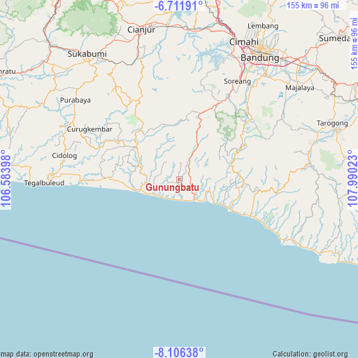
Gunungbatu GPS coordinates[2]
7° 24' 34.92" South, 107° 17' 13.56" East
| Map corner | latitude | longitude |
|---|---|---|
| Upper-left | -6.71191°, | 106.58398° |
| Center: | -7.4097°, | 107.2871° |
| Lower-right: | -8.10638°, | 107.99023° |
| Map W x H: | 155.1×155.1 km | = 96.4×96.4mi |
| max Lat: | 5.88969° ⇑53.6% North |
| Gunungbatu: | -7.4097° |
| min Lat: | ⇓46.4% South -10.934° |
| min Long | Gunungbatu | max Long |
| 95.1345° | 107.2871° | 140.9419° |
| W 15.6%⇐ | ⇒84.4% E |
Elevation
Elevation of Gunungbatu is 327 m = 1073 ft, and this is 97.3 m = 319 ft above average elevation for this country.
| Max E: |
3185 m = 10449 ft | 27.6% |
| Gunungbatu | 327 m 1073 ft | |
| Avg. | 229.7 m = 754 ft | |
Min E: |
-1 m = -3 ft | 72.4% |
See also: Indonesia elevation on elevation.city.
Geographical zone
Gunungbatu is located in South Torrid zone (between Equator and Tropic of Capricorn). Distance of Equator is 823.9 km =511.9 mi to North.| Distance of | km | miles | from Gunungbatu |
|---|---|---|---|
| Equator | 823.9 | 511.9 | to North |
| Tropic Capricorn | 1782 | 1107.3 | to South |
| Antarctic Circle | 6577.3 | 4086.9 | to South |
| South Pole | 9183.2 | 5706.2 | to South |


Nearby cities:
15 places around Gunungbatu: (largest is in red/bold)
• Ciawitali
9.1 km =5.7 mi,  99°
99°
• Cibitung
9.2 km =5.7 mi,  317°
317°
• Cikamurang
9.7 km =6 mi,  210°
210°
• Cikole
8.9 km =5.5 mi,  187°
187°
• Cimalati
8 km =5 mi,  283°
283°
• Ciparay
7.2 km =4.5 mi,  52°
52°
• Karangpawitan
10.8 km =6.7 mi, 100°
• Kebonkopi
9.1 km =5.7 mi,  202°
202°
• Kendalngupuk
5.1 km =3.2 mi,  223°
223°
• Malati
6.6 km =4.1 mi,  35°
35°
• Naringgul
9.5 km =5.9 mi,  28°
28°
• Pancalan
10.8 km =6.7 mi,  15°
15°
• Simpang
9 km =5.6 mi,  300°
300°
• Singkup
7 km =4.3 mi,  4°
4°
• Wangunjaya
4.9 km =3 mi,  78°
78°
Sources, notices
• [Note1] Compared only with cities in Indonesia existing in our database
• [Src1] Map data: © OpenStreetMap contributors (CC-BY-SA)
• [Src2] Other city data from geonames.org with taken over terms of usage.
• [Src3] Geographical zone / Annual Mean Temperature by Robert A. Rohde @ Wikipedia
