Indralayang geodata
Indralayang (West Java) is a seat of a fourth-order administrative division; located in Indonesia in Asia/Jakarta (GMT+7) time zone. In our database, there are 407 cities with bigger population. Compared to other cities in Indonesia, 55.8% of cities are located further ↑North; 84.1% of cities are located further →East and 65.9% of cities have lower elevation than Indralayang. Note1


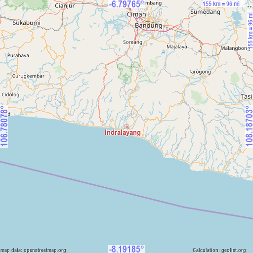
Indralayang GPS coordinates[2]
7° 29' 43.116" South, 107° 29' 2.04" East
| Map corner | latitude | longitude |
|---|---|---|
| Upper-left | -6.79765°, | 106.78078° |
| Center: | -7.49531°, | 107.4839° |
| Lower-right: | -8.19185°, | 108.18703° |
| Map W x H: | 155×155 km | = 96.3×96.3mi |
| max Lat: | 5.88969° ⇑55.8% North |
| Indralayang: | -7.49531° |
| min Lat: | ⇓44.2% South -10.934° |
| min Long | Indralayang | max Long |
| 95.1345° | 107.4839° | 140.9419° |
| W 15.9%⇐ | ⇒84.1% E |
Elevation
Elevation of Indralayang is 236 m = 774 ft, and this is 6.3 m = 21 ft above average elevation for this country.
| Max E: |
3185 m = 10449 ft | 34.1% |
| Indralayang | 236 m 774 ft | |
| Avg. | 229.7 m = 754 ft | |
Min E: |
-1 m = -3 ft | 65.9% |
See also: Indonesia elevation on elevation.city.
Geographical zone
Indralayang is located in South Torrid zone (between Equator and Tropic of Capricorn). Distance of Equator is 833.4 km =517.9 mi to North.| Distance of | km | miles | from Indralayang |
|---|---|---|---|
| Equator | 833.4 | 517.9 | to North |
| Tropic Capricorn | 1772.5 | 1101.4 | to South |
| Antarctic Circle | 6567.8 | 4081 | to South |
| South Pole | 9173.7 | 5700.3 | to South |


Nearby cities:
15 places around Indralayang: (largest is in red/bold)
• Bantarmunding
6.3 km =3.9 mi,  286°
286°
• Baranti
11.5 km =7.1 mi,  325°
325°
• Caringin
5.6 km =3.5 mi,  36°
36°
• Cibeureum
10.8 km =6.7 mi,  52°
52°
• Cijaringao
7.3 km =4.5 mi,  123°
123°
• Cijayana
11 km =6.8 mi, 124°
• Cikalaces
5.9 km =3.7 mi,  84°
84°
• Cikarang
8.4 km =5.2 mi,  336°
336°
• Cikuya
10.9 km =6.8 mi,  69°
69°
• Pasireunteung
10.5 km =6.5 mi,  94°
94°
• Puncakwangi
8.4 km =5.2 mi, 287°
• Rancabuaya
3.3 km =2.1 mi,  166°
166°
• Sukajadi
11.8 km =7.3 mi,  29°
29°
• Sukarame
8.4 km =5.2 mi, 39°
• Tegallega
8.9 km =5.5 mi, 72°
Sources, notices
• [Note1] Compared only with cities in Indonesia existing in our database
• [Src1] Map data: © OpenStreetMap contributors (CC-BY-SA)
• [Src2] Other city data from geonames.org with taken over terms of usage.
• [Src3] Geographical zone / Annual Mean Temperature by Robert A. Rohde @ Wikipedia
