Bebedahan geodata
Bebedahan (West Java) is a seat of a fourth-order administrative division; located in Indonesia in Asia/Jakarta (GMT+7) time zone. In our database, there are 407 cities with bigger population. Compared to other cities in Indonesia, 53.7% of cities are located further ↑North; 83.6% of cities are located further →East and 92.5% of cities have lower elevation than Bebedahan. Note1


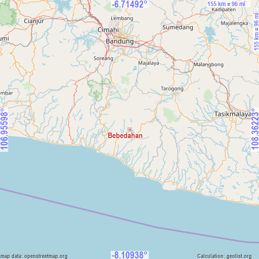
Bebedahan GPS coordinates[2]
7° 24' 45.72" South, 107° 39' 32.76" East
| Map corner | latitude | longitude |
|---|---|---|
| Upper-left | -6.71492°, | 106.95598° |
| Center: | -7.4127°, | 107.6591° |
| Lower-right: | -8.10938°, | 108.36223° |
| Map W x H: | 155×155.1 km | = 96.3×96.4mi |
| max Lat: | 5.88969° ⇑53.7% North |
| Bebedahan: | -7.4127° |
| min Lat: | ⇓46.3% South -10.934° |
| min Long | Bebedahan | max Long |
| 95.1345° | 107.6591° | 140.9419° |
| W 16.4%⇐ | ⇒83.6% E |
Elevation
Elevation of Bebedahan is 722 m = 2369 ft, and this is 492.3 m = 1615 ft above average elevation for this country.
| Max E: |
3185 m = 10449 ft | 7.5% |
| Bebedahan | 722 m 2369 ft | |
| Avg. | 229.7 m = 754 ft | |
Min E: |
-1 m = -3 ft | 92.5% |
See also: Indonesia elevation on elevation.city.
Geographical zone
Bebedahan is located in South Torrid zone (between Equator and Tropic of Capricorn). Distance of Equator is 824.2 km =512.1 mi to North.| Distance of | km | miles | from Bebedahan |
|---|---|---|---|
| Equator | 824.2 | 512.1 | to North |
| Tropic Capricorn | 1781.7 | 1107.1 | to South |
| Antarctic Circle | 6577 | 4086.8 | to South |
| South Pole | 9182.8 | 5705.9 | to South |


Nearby cities:
15 places around Bebedahan: (largest is in red/bold)
• Batutumpang
4.7 km =2.9 mi,  235°
235°
• Bungbulang
8.2 km =5.1 mi,  233°
233°
• Cibolang
6.9 km =4.3 mi,  246°
246°
• Cikopo
5 km =3.1 mi,  20°
20°
• Cisandaan
7 km =4.3 mi,  74°
74°
• Halimpu
2.4 km =1.5 mi,  159°
159°
• Kadudampit
5.3 km =3.3 mi, 159°
• Nagrak
7.9 km =4.9 mi, 241°
• Nangkaruka
2.7 km =1.7 mi,  212°
212°
• Pakenjeng
3.5 km =2.2 mi,  88°
88°
• Pasirgaru
2.2 km =1.4 mi,  81°
81°
• Pasirwangi
5.4 km =3.4 mi,  173°
173°
• Rahayu
5.5 km =3.4 mi,  197°
197°
• Simpang
6.9 km =4.3 mi, 171°
• Sindangratu
6 km =3.7 mi, 166°
Sources, notices
• [Note1] Compared only with cities in Indonesia existing in our database
• [Src1] Map data: © OpenStreetMap contributors (CC-BY-SA)
• [Src2] Other city data from geonames.org with taken over terms of usage.
• [Src3] Geographical zone / Annual Mean Temperature by Robert A. Rohde @ Wikipedia
