Nagrak geodata
Nagrak (West Java) is a seat of a fourth-order administrative division; located in Indonesia in Asia/Jakarta (GMT+7) time zone. In our database, there are 407 cities with bigger population. Compared to other cities in Indonesia, 54.5% of cities are located further ↑North; 83.8% of cities are located further →East and 83.8% of cities have lower elevation than Nagrak. Note1


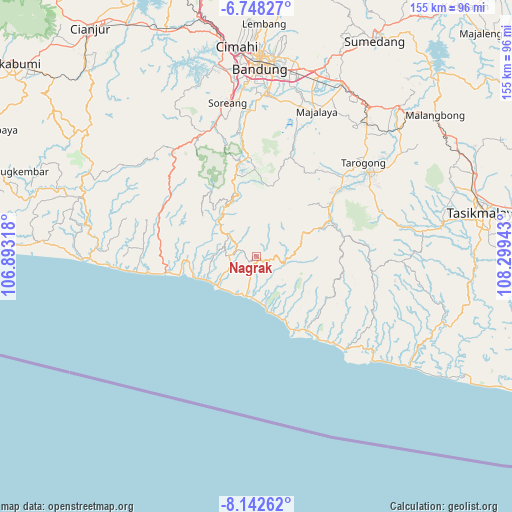
Nagrak GPS coordinates[2]
7° 26' 45.6" South, 107° 35' 46.68" East
| Map corner | latitude | longitude |
|---|---|---|
| Upper-left | -6.74827°, | 106.89318° |
| Center: | -7.446°, | 107.5963° |
| Lower-right: | -8.14262°, | 108.29943° |
| Map W x H: | 155×155 km | = 96.3×96.3mi |
| max Lat: | 5.88969° ⇑54.5% North |
| Nagrak: | -7.446° |
| min Lat: | ⇓45.5% South -10.934° |
| min Long | Nagrak | max Long |
| 95.1345° | 107.5963° | 140.9419° |
| W 16.2%⇐ | ⇒83.8% E |
Elevation
Elevation of Nagrak is 495 m = 1624 ft, and this is 265.3 m = 870 ft above average elevation for this country.
| Max E: |
3185 m = 10449 ft | 16.2% |
| Nagrak | 495 m 1624 ft | |
| Avg. | 229.7 m = 754 ft | |
Min E: |
-1 m = -3 ft | 83.8% |
See also: Indonesia elevation on elevation.city.
Geographical zone
Nagrak is located in South Torrid zone (between Equator and Tropic of Capricorn). Distance of Equator is 827.9 km =514.4 mi to North.| Distance of | km | miles | from Nagrak |
|---|---|---|---|
| Equator | 827.9 | 514.4 | to North |
| Tropic Capricorn | 1778 | 1104.8 | to South |
| Antarctic Circle | 6573.3 | 4084.5 | to South |
| South Pole | 9179.1 | 5703.6 | to South |


Nearby cities:
15 places around Nagrak: (largest is in red/bold)
• Babakansalam
7 km =4.3 mi,  152°
152°
• Batutumpang
3.2 km =2 mi,  71°
71°
• Bungbulang
1.2 km =0.7 mi,  165°
165°
• Cibeureum
4 km =2.5 mi,  285°
285°
• Cibolang
1.1 km =0.7 mi,  31°
31°
• Cikuya
2.7 km =1.7 mi,  233°
233°
• Hanjuang
2.1 km =1.3 mi,  183°
183°
• Nangkaruka
5.7 km =3.5 mi,  75°
75°
• Pamungguan
4.2 km =2.6 mi, 145°
• Pasireunteung
6.6 km =4.1 mi,  197°
197°
• Pasirwangi
7.7 km =4.8 mi,  102°
102°
• Rahayu
5.5 km =3.4 mi,  105°
105°
• Sukarame
7.1 km =4.4 mi,  277°
277°
• Tegalastana
4.5 km =2.8 mi, 176°
• Tegallega
4.8 km =3 mi, 234°
Sources, notices
• [Note1] Compared only with cities in Indonesia existing in our database
• [Src1] Map data: © OpenStreetMap contributors (CC-BY-SA)
• [Src2] Other city data from geonames.org with taken over terms of usage.
• [Src3] Geographical zone / Annual Mean Temperature by Robert A. Rohde @ Wikipedia
