Kampungpasar geodata
Kampungpasar (West Java) is a seat of a fourth-order administrative division; located in Indonesia in Asia/Jakarta (GMT+7) time zone. In our database, there are 407 cities with bigger population. Compared to other cities in Indonesia, 52.8% of cities are located further ↓South; 85.3% of cities are located further →East and 58% of cities have lower elevation than Kampungpasar. Note1


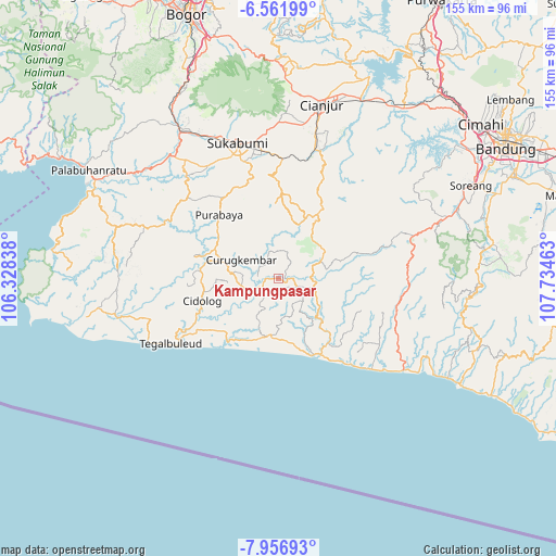
Kampungpasar GPS coordinates[2]
7° 15' 36" South, 107° 1' 53.4" East
| Map corner | latitude | longitude |
|---|---|---|
| Upper-left | -6.56199°, | 106.32838° |
| Center: | -7.26°, | 107.0315° |
| Lower-right: | -7.95693°, | 107.73463° |
| Map W x H: | 155.1×155.1 km | = 96.4×96.4mi |
| max Lat: | 5.88969° ⇑47.2% North |
| Kampungpasar: | -7.26° |
| min Lat: | ⇓52.8% South -10.934° |
| min Long | Kampungpasar | max Long |
| 95.1345° | 107.0315° | 140.9419° |
| W 14.7%⇐ | ⇒85.3% E |
Elevation
Elevation of Kampungpasar is 146 m = 479 ft, and this is 83.7 m = 275 ft below average elevation for this country.
| Max E: |
3185 m = 10449 ft | 42% |
| Avg. | 229.7 m = 754 ft | |
| Kampungpasar | 146 m = 479 ft | |
Min E: |
-1 m = -3 ft | 58% |
See also: Indonesia elevation on elevation.city.
Geographical zone
Kampungpasar is located in South Torrid zone (between Equator and Tropic of Capricorn). Distance of Equator is 807.2 km =501.6 mi to North.| Distance of | km | miles | from Kampungpasar |
|---|---|---|---|
| Equator | 807.2 | 501.6 | to North |
| Tropic Capricorn | 1798.7 | 1117.7 | to South |
| Antarctic Circle | 6593.9 | 4097.3 | to South |
| South Pole | 9199.8 | 5716.5 | to South |


Nearby cities:
15 places around Kampungpasar: (largest is in red/bold)
• Batukarut
4 km =2.5 mi,  208°
208°
• Bojonglarang
3.1 km =1.9 mi,  268°
268°
• Cibodas
1.9 km =1.2 mi,  125°
125°
• Cimanggu
1.7 km =1.1 mi,  345°
345°
• Cintasari
3.8 km =2.4 mi,  6°
6°
• Gunungwaru Satu
2.9 km =1.8 mi,  43°
43°
• Kadupandak
1.7 km =1.1 mi,  94°
94°
• Karamat
1.8 km =1.1 mi,  83°
83°
• Kebonkaret
4.9 km =3 mi,  65°
65°
• Puncakwangi
5.5 km =3.4 mi,  136°
136°
• Sawahrandu
1.2 km =0.7 mi, 268°
• Sinarbakti
4.8 km =3 mi,  248°
248°
• Sukakarya
3.7 km =2.3 mi,  316°
316°
• Tegalheras
4.3 km =2.7 mi,  118°
118°
• Tugu
2.6 km =1.6 mi, 90°
Sources, notices
• [Note1] Compared only with cities in Indonesia existing in our database
• [Src1] Map data: © OpenStreetMap contributors (CC-BY-SA)
• [Src2] Other city data from geonames.org with taken over terms of usage.
• [Src3] Geographical zone / Annual Mean Temperature by Robert A. Rohde @ Wikipedia
