Wangun geodata
Wangun (West Java) is a seat of a fourth-order administrative division; located in Indonesia in Asia/Jakarta (GMT+7) time zone. In our database, there are 407 cities with bigger population. Compared to other cities in Indonesia, 64% of cities are located further ↓South; 85% of cities are located further →East and 98.2% of cities have lower elevation than Wangun. Note1


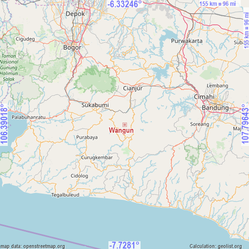
Wangun GPS coordinates[2]
7° 1' 50.88" South, 107° 5' 35.88" East
| Map corner | latitude | longitude |
|---|---|---|
| Upper-left | -6.33246°, | 106.39018° |
| Center: | -7.0308°, | 107.0933° |
| Lower-right: | -7.7281°, | 107.79643° |
| Map W x H: | 155.2×155.2 km | = 96.4×96.4mi |
| max Lat: | 5.88969° ⇑36% North |
| Wangun: | -7.0308° |
| min Lat: | ⇓64% South -10.934° |
| min Long | Wangun | max Long |
| 95.1345° | 107.0933° | 140.9419° |
| W 15%⇐ | ⇒85% E |
Elevation
Elevation of Wangun is 1055 m = 3461 ft, and this is 825.3 m = 2708 ft above average elevation for this country.
| Max E: |
3185 m = 10449 ft | 1.8% |
| Wangun | 1055 m 3461 ft | |
| Avg. | 229.7 m = 754 ft | |
Min E: |
-1 m = -3 ft | 98.2% |
See also: Indonesia elevation on elevation.city.
Geographical zone
Wangun is located in South Torrid zone (between Equator and Tropic of Capricorn). Distance of Equator is 781.8 km =485.8 mi to North.| Distance of | km | miles | from Wangun |
|---|---|---|---|
| Equator | 781.8 | 485.8 | to North |
| Tropic Capricorn | 1824.2 | 1133.5 | to South |
| Antarctic Circle | 6619.4 | 4113.1 | to South |
| South Pole | 9225.3 | 5732.3 | to South |


Nearby cities:
15 places around Wangun: (largest is in red/bold)
• Babakanlapang
5.3 km =3.3 mi,  223°
223°
• Campaka
4.3 km =2.7 mi,  94°
94°
• Caringin
8.1 km =5 mi,  142°
142°
• Cibeber
3.9 km =2.4 mi,  336°
336°
• Ciguha Tengah
9.8 km =6.1 mi,  205°
205°
• Ciodeng
9.1 km =5.7 mi,  178°
178°
• Kalibaru
7.5 km =4.7 mi,  228°
228°
• Kebonkaret
7.8 km =4.8 mi,  110°
110°
• Kupel
10.2 km =6.3 mi,  119°
119°
• Mekarjaya
7.5 km =4.7 mi,  274°
274°
• Pasirreungit
9.5 km =5.9 mi,  284°
284°
• Sukaasih
3.2 km =2 mi,  47°
47°
• Sukanagara
8.5 km =5.3 mi,  150°
150°
• Takokak
10.2 km =6.3 mi,  257°
257°
• Warungsimpang
5.6 km =3.5 mi,  69°
69°
Sources, notices
• [Note1] Compared only with cities in Indonesia existing in our database
• [Src1] Map data: © OpenStreetMap contributors (CC-BY-SA)
• [Src2] Other city data from geonames.org with taken over terms of usage.
• [Src3] Geographical zone / Annual Mean Temperature by Robert A. Rohde @ Wikipedia
