Kupel geodata
Kupel (West Java) is a seat of a fourth-order administrative division; located in Indonesia in Asia/Jakarta (GMT+7) time zone. In our database, there are 407 cities with bigger population. Compared to other cities in Indonesia, 61.2% of cities are located further ↓South; 84.6% of cities are located further →East and 97.5% of cities have lower elevation than Kupel. Note1


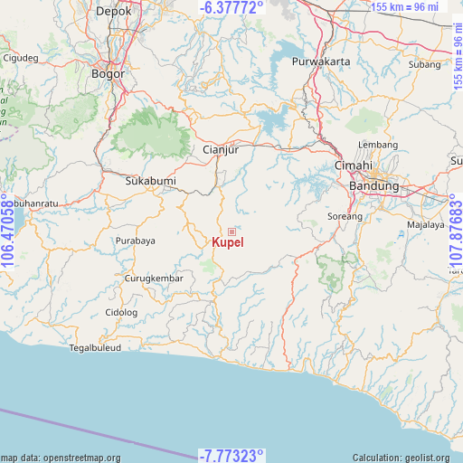
Kupel GPS coordinates[2]
7° 4' 33.6" South, 107° 10' 25.32" East
| Map corner | latitude | longitude |
|---|---|---|
| Upper-left | -6.37772°, | 106.47058° |
| Center: | -7.076°, | 107.1737° |
| Lower-right: | -7.77323°, | 107.87683° |
| Map W x H: | 155.2×155.2 km | = 96.4×96.4mi |
| max Lat: | 5.88969° ⇑38.8% North |
| Kupel: | -7.076° |
| min Lat: | ⇓61.2% South -10.934° |
| min Long | Kupel | max Long |
| 95.1345° | 107.1737° | 140.9419° |
| W 15.4%⇐ | ⇒84.6% E |
Elevation
Elevation of Kupel is 999 m = 3278 ft, and this is 769.3 m = 2524 ft above average elevation for this country.
| Max E: |
3185 m = 10449 ft | 2.5% |
| Kupel | 999 m 3278 ft | |
| Avg. | 229.7 m = 754 ft | |
Min E: |
-1 m = -3 ft | 97.5% |
See also: Indonesia elevation on elevation.city.
Geographical zone
Kupel is located in South Torrid zone (between Equator and Tropic of Capricorn). Distance of Equator is 786.8 km =488.9 mi to North.| Distance of | km | miles | from Kupel |
|---|---|---|---|
| Equator | 786.8 | 488.9 | to North |
| Tropic Capricorn | 1819.1 | 1130.3 | to South |
| Antarctic Circle | 6614.4 | 4110 | to South |
| South Pole | 9220.3 | 5729.2 | to South |


Nearby cities:
15 places around Kupel: (largest is in red/bold)
• Campaka
6.6 km =4.1 mi,  315°
315°
• Caringin
4.2 km =2.6 mi,  251°
251°
• Cibitung
6.7 km =4.2 mi,  224°
224°
• Ciherang
4.8 km =3 mi,  67°
67°
• Ciodeng
9.5 km =5.9 mi,  244°
244°
• Citamiang
3.3 km =2.1 mi,  81°
81°
• Kebonkaret
2.8 km =1.7 mi, 324°
• Nagrog
7.7 km =4.8 mi,  53°
53°
• Parabon
9.5 km =5.9 mi, 222°
• Sukaasih
9.7 km =6 mi, 317°
• Sukanagara
5.3 km =3.3 mi, 242°
• Tegallega
6.3 km =3.9 mi,  58°
58°
• Walagar
2.5 km =1.6 mi,  85°
85°
• Wangun
10.2 km =6.3 mi,  299°
299°
• Warungsimpang
7.9 km =4.9 mi,  332°
332°
Sources, notices
• [Note1] Compared only with cities in Indonesia existing in our database
• [Src1] Map data: © OpenStreetMap contributors (CC-BY-SA)
• [Src2] Other city data from geonames.org with taken over terms of usage.
• [Src3] Geographical zone / Annual Mean Temperature by Robert A. Rohde @ Wikipedia
