Simpang geodata
Simpang (West Java) is a seat of a fourth-order administrative division; located in Indonesia in Asia/Jakarta (GMT+7) time zone. In our database, there are 407 cities with bigger population. Compared to other cities in Indonesia, 52% of cities are located further ↑North; 83.2% of cities are located further →East and 99.4% of cities have lower elevation than Simpang. Note1


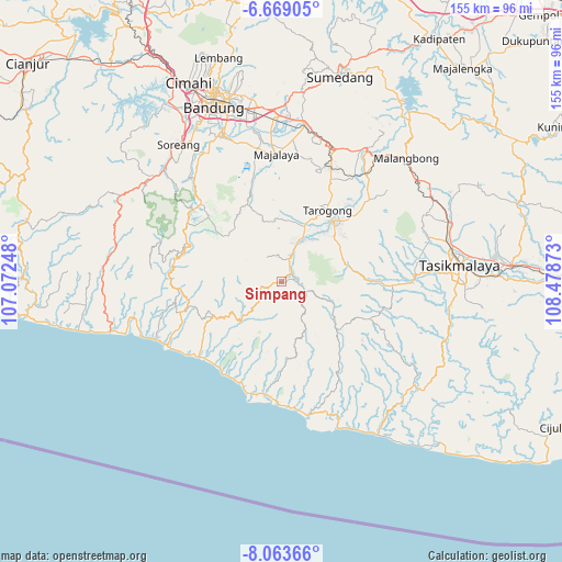
Simpang GPS coordinates[2]
7° 22' 0.84" South, 107° 46' 32.16" East
| Map corner | latitude | longitude |
|---|---|---|
| Upper-left | -6.66905°, | 107.07248° |
| Center: | -7.3669°, | 107.7756° |
| Lower-right: | -8.06366°, | 108.47873° |
| Map W x H: | 155.1×155.1 km | = 96.4×96.4mi |
| max Lat: | 5.88969° ⇑52% North |
| Simpang: | -7.3669° |
| min Lat: | ⇓48% South -10.934° |
| min Long | Simpang | max Long |
| 95.1345° | 107.7756° | 140.9419° |
| W 16.8%⇐ | ⇒83.2% E |
Elevation
Elevation of Simpang is 1291 m = 4236 ft, and this is 1061.3 m = 3482 ft above average elevation for this country.
| Max E: |
3185 m = 10449 ft | 0.59999999999999% |
| Simpang | 1291 m 4236 ft | |
| Avg. | 229.7 m = 754 ft | |
Min E: |
-1 m = -3 ft | 99.4% |
See also: Indonesia elevation on elevation.city.
Geographical zone
Simpang is located in South Torrid zone (between Equator and Tropic of Capricorn). Distance of Equator is 819.1 km =509 mi to North.| Distance of | km | miles | from Simpang |
|---|---|---|---|
| Equator | 819.1 | 509 | to North |
| Tropic Capricorn | 1786.8 | 1110.3 | to South |
| Antarctic Circle | 6582.1 | 4089.9 | to South |
| South Pole | 9187.9 | 5709.1 | to South |


Nearby cities:
15 places around Simpang: (largest is in red/bold)
• Barusuda
4.4 km =2.7 mi,  68°
68°
• Cibodas
4.3 km =2.7 mi,  83°
83°
• Cidatar Kulon
4.8 km =3 mi,  24°
24°
• Cigeudeug
5.3 km =3.3 mi,  41°
41°
• Ciharus
5.1 km =3.2 mi,  107°
107°
• Cikajang
3.8 km =2.4 mi, 74°
• Cikandang
2.2 km =1.4 mi,  264°
264°
• Cipaku
2.3 km =1.4 mi, 259°
• Cisero
5.5 km =3.4 mi, 21°
• Desakolot
5 km =3.1 mi, 42°
• Giriawas
5 km =3.1 mi,  86°
86°
• Padasono
3.3 km =2.1 mi, 68°
• Panyingkiran
1.5 km =0.9 mi, 20°
• Sirnagalih
3.2 km =2 mi,  55°
55°
• Sukatani
3 km =1.9 mi,  28°
28°
Sources, notices
• [Note1] Compared only with cities in Indonesia existing in our database
• [Src1] Map data: © OpenStreetMap contributors (CC-BY-SA)
• [Src2] Other city data from geonames.org with taken over terms of usage.
• [Src3] Geographical zone / Annual Mean Temperature by Robert A. Rohde @ Wikipedia
