Desakolot geodata
Desakolot (West Java) is a seat of a fourth-order administrative division; located in Indonesia in Asia/Jakarta (GMT+7) time zone. In our database, there are 407 cities with bigger population. Compared to other cities in Indonesia, 50.5% of cities are located further ↑North; 83% of cities are located further →East and 99.1% of cities have lower elevation than Desakolot. Note1


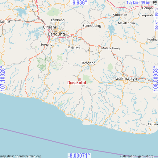
Desakolot GPS coordinates[2]
7° 20' 2.04" South, 107° 48' 23.04" East
| Map corner | latitude | longitude |
|---|---|---|
| Upper-left | -6.636°, | 107.10328° |
| Center: | -7.3339°, | 107.8064° |
| Lower-right: | -8.03071°, | 108.50953° |
| Map W x H: | 155.1×155.1 km | = 96.4×96.4mi |
| max Lat: | 5.88969° ⇑50.5% North |
| Desakolot: | -7.3339° |
| min Lat: | ⇓49.5% South -10.934° |
| min Long | Desakolot | max Long |
| 95.1345° | 107.8064° | 140.9419° |
| W 17%⇐ | ⇒83% E |
Elevation
Elevation of Desakolot is 1228 m = 4029 ft, and this is 998.3 m = 3275 ft above average elevation for this country.
| Max E: |
3185 m = 10449 ft | 0.90000000000001% |
| Desakolot | 1228 m 4029 ft | |
| Avg. | 229.7 m = 754 ft | |
Min E: |
-1 m = -3 ft | 99.1% |
See also: Indonesia elevation on elevation.city.
Geographical zone
Desakolot is located in South Torrid zone (between Equator and Tropic of Capricorn). Distance of Equator is 815.5 km =506.7 mi to North.| Distance of | km | miles | from Desakolot |
|---|---|---|---|
| Equator | 815.5 | 506.7 | to North |
| Tropic Capricorn | 1790.5 | 1112.6 | to South |
| Antarctic Circle | 6585.7 | 4092.2 | to South |
| South Pole | 9191.6 | 5711.4 | to South |


Nearby cities:
15 places around Desakolot: (largest is in red/bold)
• Barusuda
2.2 km =1.4 mi,  161°
161°
• Cibodas
3.3 km =2.1 mi, 164°
• Cidatar Kulon
1.5 km =0.9 mi,  296°
296°
• Cigeudeug
0.3 km =0.2 mi,  11°
11°
• Cikajang
2.7 km =1.7 mi,  174°
174°
• Cisero
2 km =1.2 mi,  316°
316°
• Giriawas
3.7 km =2.3 mi,  153°
153°
• Gudang
3.2 km =2 mi,  340°
340°
• Kandangsapi
2.3 km =1.4 mi, 13°
• Padasono
2.5 km =1.6 mi,  187°
187°
• Paledang
3.2 km =2 mi,  327°
327°
• Panyingkiran
3.6 km =2.2 mi,  232°
232°
• Pasar Kidul
2.9 km =1.8 mi, 331°
• Sirnagalih
2 km =1.2 mi,  201°
201°
• Sukatani
2.2 km =1.4 mi,  241°
241°
Sources, notices
• [Note1] Compared only with cities in Indonesia existing in our database
• [Src1] Map data: © OpenStreetMap contributors (CC-BY-SA)
• [Src2] Other city data from geonames.org with taken over terms of usage.
• [Src3] Geographical zone / Annual Mean Temperature by Robert A. Rohde @ Wikipedia
