Pasar Kidul geodata
Pasar Kidul (West Java) is a seat of a fourth-order administrative division; located in Indonesia in Asia/Jakarta (GMT+7) time zone. In our database, there are 407 cities with bigger population. Compared to other cities in Indonesia, 50.6% of cities are located further ↓South; 83.1% of cities are located further →East and 99.1% of cities have lower elevation than Pasar Kidul. Note1


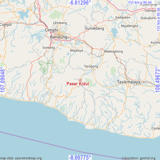
Pasar Kidul GPS coordinates[2]
7° 18' 39.24" South, 107° 47' 36.96" East
| Map corner | latitude | longitude |
|---|---|---|
| Upper-left | -6.61296°, | 107.09048° |
| Center: | -7.3109°, | 107.7936° |
| Lower-right: | -8.00775°, | 108.49673° |
| Map W x H: | 155.1×155.1 km | = 96.4×96.4mi |
| max Lat: | 5.88969° ⇑49.4% North |
| Pasar Kidul: | -7.3109° |
| min Lat: | ⇓50.6% South -10.934° |
| min Long | Pasar Kidul | max Long |
| 95.1345° | 107.7936° | 140.9419° |
| W 16.9%⇐ | ⇒83.1% E |
Elevation
Elevation of Pasar Kidul is 1227 m = 4026 ft, and this is 997.3 m = 3272 ft above average elevation for this country.
| Max E: |
3185 m = 10449 ft | 0.90000000000001% |
| Pasar Kidul | 1227 m 4026 ft | |
| Avg. | 229.7 m = 754 ft | |
Min E: |
-1 m = -3 ft | 99.1% |
See also: Indonesia elevation on elevation.city.
Geographical zone
Pasar Kidul is located in South Torrid zone (between Equator and Tropic of Capricorn). Distance of Equator is 812.9 km =505.1 mi to North.| Distance of | km | miles | from Pasar Kidul |
|---|---|---|---|
| Equator | 812.9 | 505.1 | to North |
| Tropic Capricorn | 1793 | 1114.1 | to South |
| Antarctic Circle | 6588.3 | 4093.8 | to South |
| South Pole | 9194.2 | 5713 | to South |


Nearby cities:
15 places around Pasar Kidul: (largest is in red/bold)
• Cicayur
4 km =2.5 mi,  46°
46°
• Cidatar Kulon
1.9 km =1.2 mi,  178°
178°
• Cigeudeug
2.7 km =1.7 mi,  146°
146°
• Cigintung
3.9 km =2.4 mi,  24°
24°
• Cisero
1.1 km =0.7 mi, 178°
• Ciwaru
2 km =1.2 mi,  336°
336°
• Desakolot
2.9 km =1.8 mi, 151°
• Gudang
0.6 km =0.4 mi,  38°
38°
• Kandangsapi
2 km =1.2 mi,  99°
99°
• Losari
2.4 km =1.5 mi,  31°
31°
• Nagaracinta
3 km =1.9 mi, 48°
• Negla
4.2 km =2.6 mi, 340°
• Paledang
0.3 km =0.2 mi,  295°
295°
• Pangauban
4.3 km =2.7 mi,  14°
14°
• Sukatani
3.7 km =2.3 mi,  188°
188°
Sources, notices
• [Note1] Compared only with cities in Indonesia existing in our database
• [Src1] Map data: © OpenStreetMap contributors (CC-BY-SA)
• [Src2] Other city data from geonames.org with taken over terms of usage.
• [Src3] Geographical zone / Annual Mean Temperature by Robert A. Rohde @ Wikipedia
