Balemoyan geodata
Balemoyan (West Java) is a seat of a fourth-order administrative division; located in Indonesia in Asia/Jakarta (GMT+7) time zone. In our database, there are 407 cities with bigger population. Compared to other cities in Indonesia, 50.3% of cities are located further ↓South; 81.1% of cities are located further →East and 96.3% of cities have lower elevation than Balemoyan. Note1


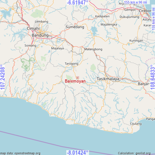
Balemoyan GPS coordinates[2]
7° 19' 2.64" South, 107° 56' 42.72" East
| Map corner | latitude | longitude |
|---|---|---|
| Upper-left | -6.61947°, | 107.24208° |
| Center: | -7.3174°, | 107.9452° |
| Lower-right: | -8.01424°, | 108.64833° |
| Map W x H: | 155.1×155.1 km | = 96.4×96.4mi |
| max Lat: | 5.88969° ⇑49.7% North |
| Balemoyan: | -7.3174° |
| min Lat: | ⇓50.3% South -10.934° |
| min Long | Balemoyan | max Long |
| 95.1345° | 107.9452° | 140.9419° |
| W 18.9%⇐ | ⇒81.1% E |
Elevation
Elevation of Balemoyan is 898 m = 2946 ft, and this is 668.3 m = 2193 ft above average elevation for this country.
| Max E: |
3185 m = 10449 ft | 3.7% |
| Balemoyan | 898 m 2946 ft | |
| Avg. | 229.7 m = 754 ft | |
Min E: |
-1 m = -3 ft | 96.3% |
See also: Indonesia elevation on elevation.city.
Geographical zone
Balemoyan is located in South Torrid zone (between Equator and Tropic of Capricorn). Distance of Equator is 813.6 km =505.5 mi to North.| Distance of | km | miles | from Balemoyan |
|---|---|---|---|
| Equator | 813.6 | 505.5 | to North |
| Tropic Capricorn | 1792.3 | 1113.7 | to South |
| Antarctic Circle | 6587.6 | 4093.3 | to South |
| South Pole | 9193.4 | 5712.5 | to South |


Nearby cities:
15 places around Balemoyan: (largest is in red/bold)
• Babakan Loak
4.6 km =2.9 mi,  308°
308°
• Bojongloa
1.4 km =0.9 mi,  258°
258°
• Cigadog
4.7 km =2.9 mi,  326°
326°
• Cigalontang
6.6 km =4.1 mi,  94°
94°
• Cigarungsang
3.3 km =2.1 mi, 313°
• Cihideung
2.5 km =1.6 mi,  302°
302°
• Cilated
3.2 km =2 mi,  119°
119°
• Cilawu
5.2 km =3.2 mi, 327°
• Cinyawar
2.9 km =1.8 mi,  234°
234°
• Citeguh
2.3 km =1.4 mi,  163°
163°
• Langkop
6.3 km =3.9 mi,  138°
138°
• Nangtang
5.7 km =3.5 mi,  126°
126°
• Pangalengan
4 km =2.5 mi,  145°
145°
• Pasirhuni
2.8 km =1.7 mi,  323°
323°
• Sukamukti
6.2 km =3.9 mi,  185°
185°
Sources, notices
• [Note1] Compared only with cities in Indonesia existing in our database
• [Src1] Map data: © OpenStreetMap contributors (CC-BY-SA)
• [Src2] Other city data from geonames.org with taken over terms of usage.
• [Src3] Geographical zone / Annual Mean Temperature by Robert A. Rohde @ Wikipedia
