Langkop geodata
Langkop (West Java) is a seat of a fourth-order administrative division; located in Indonesia in Asia/Jakarta (GMT+7) time zone. In our database, there are 407 cities with bigger population. Compared to other cities in Indonesia, 51.7% of cities are located further ↑North; 80.5% of cities are located further →East and 91.3% of cities have lower elevation than Langkop. Note1


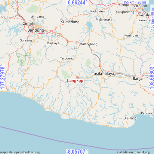
Langkop GPS coordinates[2]
7° 21' 37.08" South, 107° 58' 58.44" East
| Map corner | latitude | longitude |
|---|---|---|
| Upper-left | -6.66244°, | 107.27978° |
| Center: | -7.3603°, | 107.9829° |
| Lower-right: | -8.05707°, | 108.68603° |
| Map W x H: | 155.1×155.1 km | = 96.4×96.4mi |
| max Lat: | 5.88969° ⇑51.7% North |
| Langkop: | -7.3603° |
| min Lat: | ⇓48.3% South -10.934° |
| min Long | Langkop | max Long |
| 95.1345° | 107.9829° | 140.9419° |
| W 19.5%⇐ | ⇒80.5% E |
Elevation
Elevation of Langkop is 687 m = 2254 ft, and this is 457.3 m = 1500 ft above average elevation for this country.
| Max E: |
3185 m = 10449 ft | 8.7% |
| Langkop | 687 m 2254 ft | |
| Avg. | 229.7 m = 754 ft | |
Min E: |
-1 m = -3 ft | 91.3% |
See also: Indonesia elevation on elevation.city.
Geographical zone
Langkop is located in South Torrid zone (between Equator and Tropic of Capricorn). Distance of Equator is 818.4 km =508.5 mi to North.| Distance of | km | miles | from Langkop |
|---|---|---|---|
| Equator | 818.4 | 508.5 | to North |
| Tropic Capricorn | 1787.5 | 1110.7 | to South |
| Antarctic Circle | 6582.8 | 4090.4 | to South |
| South Pole | 9188.7 | 5709.6 | to South |


Nearby cities:
15 places around Langkop: (largest is in red/bold)
• Cibongkok
5 km =3.1 mi,  128°
128°
• Cigalontang
4.9 km =3 mi,  30°
30°
• Cilated
3.5 km =2.2 mi,  336°
336°
• Citeguh
4.3 km =2.7 mi,  306°
306°
• Jayapura
5.5 km =3.4 mi,  80°
80°
• Lajaluhur
3.1 km =1.9 mi, 75°
• Mandalasari
5.2 km =3.2 mi,  172°
172°
• Nangtang
1.4 km =0.9 mi,  18°
18°
• Pangalengan
2.4 km =1.5 mi, 307°
• Pawitan
1.7 km =1.1 mi,  109°
109°
• Pepayan
4.4 km =2.7 mi,  99°
99°
• Salawi
3.6 km =2.2 mi,  54°
54°
• Sukamanah
3.7 km =2.3 mi, 171°
• Sukamukti
5 km =3.1 mi,  253°
253°
• Sundawenang
2.1 km =1.3 mi, 127°
Sources, notices
• [Note1] Compared only with cities in Indonesia existing in our database
• [Src1] Map data: © OpenStreetMap contributors (CC-BY-SA)
• [Src2] Other city data from geonames.org with taken over terms of usage.
• [Src3] Geographical zone / Annual Mean Temperature by Robert A. Rohde @ Wikipedia
