Jayapura geodata
Jayapura (West Java) is a seat of a third-order administrative division; located in Indonesia in Asia/Jakarta (GMT+7) time zone. In our database, there are 407 cities with bigger population. Compared to other cities in Indonesia, 51.4% of cities are located further ↑North; 79.5% of cities are located further →East and 88.5% of cities have lower elevation than Jayapura. Note1


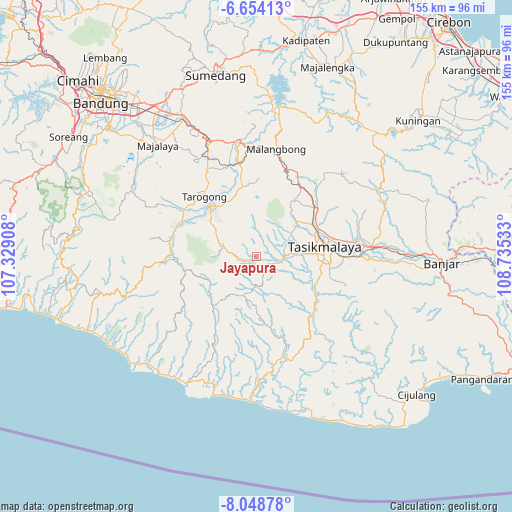
Jayapura GPS coordinates[2]
7° 21' 7.2" South, 108° 1' 55.92" East
| Map corner | latitude | longitude |
|---|---|---|
| Upper-left | -6.65413°, | 107.32908° |
| Center: | -7.352°, | 108.0322° |
| Lower-right: | -8.04878°, | 108.73533° |
| Map W x H: | 155.1×155.1 km | = 96.4×96.4mi |
| max Lat: | 5.88969° ⇑51.4% North |
| Jayapura: | -7.352° |
| min Lat: | ⇓48.6% South -10.934° |
| min Long | Jayapura | max Long |
| 95.1345° | 108.0322° | 140.9419° |
| W 20.5%⇐ | ⇒79.5% E |
Elevation
Elevation of Jayapura is 596 m = 1955 ft, and this is 366.3 m = 1202 ft above average elevation for this country.
| Max E: |
3185 m = 10449 ft | 11.5% |
| Jayapura | 596 m 1955 ft | |
| Avg. | 229.7 m = 754 ft | |
Min E: |
-1 m = -3 ft | 88.5% |
See also: Indonesia elevation on elevation.city.
Geographical zone
Jayapura is located in South Torrid zone (between Equator and Tropic of Capricorn). Distance of Equator is 817.5 km =508 mi to North.| Distance of | km | miles | from Jayapura |
|---|---|---|---|
| Equator | 817.5 | 508 | to North |
| Tropic Capricorn | 1788.5 | 1111.3 | to South |
| Antarctic Circle | 6583.7 | 4090.9 | to South |
| South Pole | 9189.6 | 5710.2 | to South |


Nearby cities:
15 places around Jayapura: (largest is in red/bold)
• Cibongkok
4.3 km =2.7 mi,  201°
201°
• Cimonyong
3.1 km =1.9 mi,  347°
347°
• Ciuyah
2.9 km =1.8 mi,  87°
87°
• Lajaluhur
2.5 km =1.6 mi,  266°
266°
• Nagrog
4.2 km =2.6 mi,  183°
183°
• Pacihayan
3.4 km =2.1 mi,  3°
3°
• Parawan
2.2 km =1.4 mi,  102°
102°
• Pawitan
4.1 km =2.5 mi,  249°
249°
• Pepayan
2 km =1.2 mi,  213°
213°
• Pesantren
2.8 km =1.7 mi,  139°
139°
• Rancapeundey
4.4 km =2.7 mi,  58°
58°
• Salawi
2.8 km =1.7 mi,  295°
295°
• Salawu
2.6 km =1.6 mi, 179°
• Sundawenang
4.3 km =2.7 mi,  239°
239°
• Warungpeuteuy
3.3 km =2.1 mi,  148°
148°
Sources, notices
• [Note1] Compared only with cities in Indonesia existing in our database
• [Src1] Map data: © OpenStreetMap contributors (CC-BY-SA)
• [Src2] Other city data from geonames.org with taken over terms of usage.
• [Src3] Geographical zone / Annual Mean Temperature by Robert A. Rohde @ Wikipedia
