Pasirjengkol geodata
Pasirjengkol (West Java) is a seat of a fourth-order administrative division; located in Indonesia in Asia/Jakarta (GMT+7) time zone. In our database, there are 407 cities with bigger population. Compared to other cities in Indonesia, 58.8% of cities are located further ↓South; 80.2% of cities are located further →East and 91.1% of cities have lower elevation than Pasirjengkol. Note1


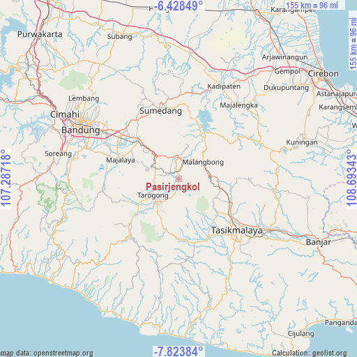
Pasirjengkol GPS coordinates[2]
7° 7' 36.12" South, 107° 59' 25.08" East
| Map corner | latitude | longitude |
|---|---|---|
| Upper-left | -6.42849°, | 107.28718° |
| Center: | -7.1267°, | 107.9903° |
| Lower-right: | -7.82384°, | 108.69343° |
| Map W x H: | 155.1×155.2 km | = 96.4×96.4mi |
| max Lat: | 5.88969° ⇑41.2% North |
| Pasirjengkol: | -7.1267° |
| min Lat: | ⇓58.8% South -10.934° |
| min Long | Pasirjengkol | max Long |
| 95.1345° | 107.9903° | 140.9419° |
| W 19.8%⇐ | ⇒80.2% E |
Elevation
Elevation of Pasirjengkol is 680 m = 2231 ft, and this is 450.3 m = 1477 ft above average elevation for this country.
| Max E: |
3185 m = 10449 ft | 8.9% |
| Pasirjengkol | 680 m 2231 ft | |
| Avg. | 229.7 m = 754 ft | |
Min E: |
-1 m = -3 ft | 91.1% |
See also: Indonesia elevation on elevation.city.
Geographical zone
Pasirjengkol is located in South Torrid zone (between Equator and Tropic of Capricorn). Distance of Equator is 792.4 km =492.4 mi to North.| Distance of | km | miles | from Pasirjengkol |
|---|---|---|---|
| Equator | 792.4 | 492.4 | to North |
| Tropic Capricorn | 1813.5 | 1126.9 | to South |
| Antarctic Circle | 6608.8 | 4106.5 | to South |
| South Pole | 9214.6 | 5725.7 | to South |


Nearby cities:
15 places around Pasirjengkol: (largest is in red/bold)
• Babakanloa
3.1 km =1.9 mi,  337°
337°
• Babgot
2.8 km =1.7 mi,  129°
129°
• Batukarut
2.4 km =1.5 mi,  242°
242°
• Cibeureum
3.7 km =2.3 mi,  174°
174°
• Cibodas
3.4 km =2.1 mi,  351°
351°
• Gununglimbangan
2.9 km =1.8 mi, 346°
• Jembatandua
1.1 km =0.7 mi,  194°
194°
• Kostarea Satu
3.1 km =1.9 mi, 133°
• Neglasari
0.5 km =0.3 mi,  90°
90°
• Pangatikan
3.1 km =1.9 mi,  184°
184°
• Sikluk
3.3 km =2.1 mi,  271°
271°
• Sindangkerta
2 km =1.2 mi, 339°
• Sukagalih
2.5 km =1.6 mi,  211°
211°
• Tagog
0.7 km =0.4 mi,  24°
24°
• Wanakerta
2.6 km =1.6 mi, 351°
Sources, notices
• [Note1] Compared only with cities in Indonesia existing in our database
• [Src1] Map data: © OpenStreetMap contributors (CC-BY-SA)
• [Src2] Other city data from geonames.org with taken over terms of usage.
• [Src3] Geographical zone / Annual Mean Temperature by Robert A. Rohde @ Wikipedia
