Cigorowong Kidul geodata
Cigorowong Kidul (West Java) is a seat of a fourth-order administrative division; located in Indonesia in Asia/Jakarta (GMT+7) time zone. In our database, there are 407 cities with bigger population. Compared to other cities in Indonesia, 64.5% of cities are located further ↓South; 82.3% of cities are located further →East and 95.7% of cities have lower elevation than Cigorowong Kidul. Note1


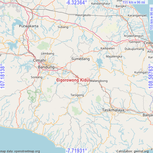
Cigorowong Kidul GPS coordinates[2]
7° 1' 19.2" South, 107° 53' 4.2" East
| Map corner | latitude | longitude |
|---|---|---|
| Upper-left | -6.32364°, | 107.18138° |
| Center: | -7.022°, | 107.8845° |
| Lower-right: | -7.71931°, | 108.58763° |
| Map W x H: | 155.2×155.2 km | = 96.4×96.4mi |
| max Lat: | 5.88969° ⇑35.5% North |
| Cigorowong Kidul: | -7.022° |
| min Lat: | ⇓64.5% South -10.934° |
| min Long | Cigorowong Kidu | max Long |
| 95.1345° | 107.8845° | 140.9419° |
| W 17.7%⇐ | ⇒82.3% E |
Elevation
Elevation of Cigorowong Kidul is 857 m = 2812 ft, and this is 627.3 m = 2058 ft above average elevation for this country.
| Max E: |
3185 m = 10449 ft | 4.3% |
| Cigorowong Kidul | 857 m 2812 ft | |
| Avg. | 229.7 m = 754 ft | |
Min E: |
-1 m = -3 ft | 95.7% |
See also: Indonesia elevation on elevation.city.
Geographical zone
Cigorowong Kidul is located in South Torrid zone (between Equator and Tropic of Capricorn). Distance of Equator is 780.8 km =485.2 mi to North.| Distance of | km | miles | from Cigorowong Kidul |
|---|---|---|---|
| Equator | 780.8 | 485.2 | to North |
| Tropic Capricorn | 1825.1 | 1134.1 | to South |
| Antarctic Circle | 6620.4 | 4113.7 | to South |
| South Pole | 9226.3 | 5733 | to South |


Nearby cities:
15 places around Cigorowong Kidul: (largest is in red/bold)
• Batugede Kulon
7.1 km =4.4 mi,  153°
153°
• Ciaro
4.3 km =2.7 mi,  114°
114°
• Ciburial
3.2 km =2 mi,  127°
127°
• Cihuni
5.7 km =3.5 mi,  162°
162°
• Cipeundeuy
6.2 km =3.9 mi,  172°
172°
• Halteu
7 km =4.3 mi, 166°
• Haruman
7.2 km =4.5 mi,  140°
140°
• Karangtengah
5.9 km =3.7 mi, 171°
• Margabakti
1.2 km =0.7 mi,  318°
318°
• Saar Kaler
4.5 km =2.8 mi,  97°
97°
• Sinarbakti
6 km =3.7 mi, 151°
• Sukasari
6.1 km =3.8 mi, 169°
• Talun
6.6 km =4.1 mi,  123°
123°
• Tangulun
6.5 km =4 mi, 143°
• Tegallame
6.2 km =3.9 mi, 106°
Sources, notices
• [Note1] Compared only with cities in Indonesia existing in our database
• [Src1] Map data: © OpenStreetMap contributors (CC-BY-SA)
• [Src2] Other city data from geonames.org with taken over terms of usage.
• [Src3] Geographical zone / Annual Mean Temperature by Robert A. Rohde @ Wikipedia
