Tegallame geodata
Tegallame (West Java) is a seat of a fourth-order administrative division; located in Indonesia in Asia/Jakarta (GMT+7) time zone. In our database, there are 407 cities with bigger population. Compared to other cities in Indonesia, 63.4% of cities are located further ↓South; 81.2% of cities are located further →East and 90.1% of cities have lower elevation than Tegallame. Note1


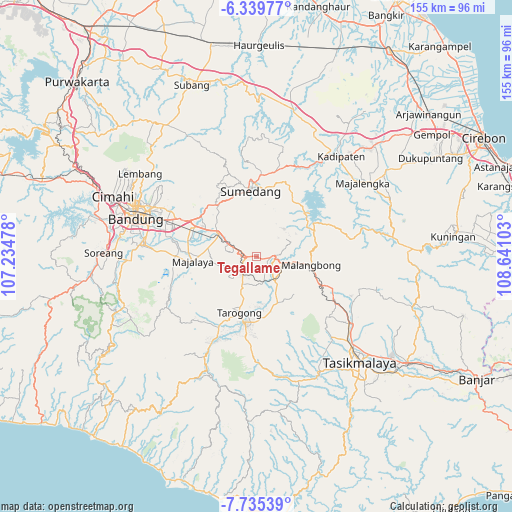
Tegallame GPS coordinates[2]
7° 2' 17.16" South, 107° 56' 16.44" East
| Map corner | latitude | longitude |
|---|---|---|
| Upper-left | -6.33977°, | 107.23478° |
| Center: | -7.0381°, | 107.9379° |
| Lower-right: | -7.73539°, | 108.64103° |
| Map W x H: | 155.2×155.2 km | = 96.4×96.4mi |
| max Lat: | 5.88969° ⇑36.6% North |
| Tegallame: | -7.0381° |
| min Lat: | ⇓63.4% South -10.934° |
| min Long | Tegallame | max Long |
| 95.1345° | 107.9379° | 140.9419° |
| W 18.8%⇐ | ⇒81.2% E |
Elevation
Elevation of Tegallame is 645 m = 2116 ft, and this is 415.3 m = 1363 ft above average elevation for this country.
| Max E: |
3185 m = 10449 ft | 9.9% |
| Tegallame | 645 m 2116 ft | |
| Avg. | 229.7 m = 754 ft | |
Min E: |
-1 m = -3 ft | 90.1% |
See also: Indonesia elevation on elevation.city.
Geographical zone
Tegallame is located in South Torrid zone (between Equator and Tropic of Capricorn). Distance of Equator is 782.6 km =486.3 mi to North.| Distance of | km | miles | from Tegallame |
|---|---|---|---|
| Equator | 782.6 | 486.3 | to North |
| Tropic Capricorn | 1823.4 | 1133 | to South |
| Antarctic Circle | 6618.6 | 4112.6 | to South |
| South Pole | 9224.5 | 5731.8 | to South |


Nearby cities:
15 places around Tegallame: (largest is in red/bold)
• Babakandesa
3.6 km =2.2 mi,  108°
108°
• Bunisari
4.6 km =2.9 mi,  145°
145°
• Burujul
4.2 km =2.6 mi,  89°
89°
• Ciaro
2 km =1.2 mi,  269°
269°
• Ciburial
3.3 km =2.1 mi, 267°
• Cigagade
2.1 km =1.3 mi,  104°
104°
• Cilolongokan
3.7 km =2.3 mi, 89°
• Haruman
4 km =2.5 mi,  198°
198°
• Ikar
4.4 km =2.7 mi,  63°
63°
• Saar Kaler
1.8 km =1.1 mi,  310°
310°
• Sinarbakti
4.6 km =2.9 mi,  220°
220°
• Situbatu
4.8 km =3 mi, 153°
• Sukasari
4.4 km =2.7 mi,  139°
139°
• Talun
1.9 km =1.2 mi,  190°
190°
• Tangulun
4 km =2.5 mi,  210°
210°
Sources, notices
• [Note1] Compared only with cities in Indonesia existing in our database
• [Src1] Map data: © OpenStreetMap contributors (CC-BY-SA)
• [Src2] Other city data from geonames.org with taken over terms of usage.
• [Src3] Geographical zone / Annual Mean Temperature by Robert A. Rohde @ Wikipedia
