Cimaung geodata
Cimaung (West Java) is a seat of a fourth-order administrative division; located in Indonesia in Asia/Jakarta (GMT+7) time zone. In our database, there are 407 cities with bigger population. Compared to other cities in Indonesia, 53.3% of cities are located further ↑North; 78.7% of cities are located further →East and 77.9% of cities have lower elevation than Cimaung. Note1


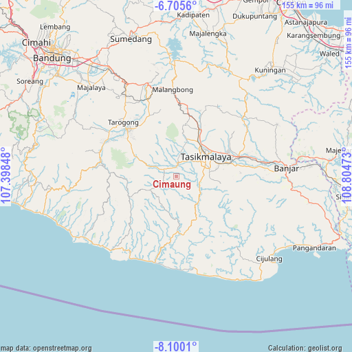
Cimaung GPS coordinates[2]
7° 24' 12.24" South, 108° 6' 5.76" East
| Map corner | latitude | longitude |
|---|---|---|
| Upper-left | -6.7056°, | 107.39848° |
| Center: | -7.4034°, | 108.1016° |
| Lower-right: | -8.1001°, | 108.80473° |
| Map W x H: | 155.1×155.1 km | = 96.4×96.4mi |
| max Lat: | 5.88969° ⇑53.3% North |
| Cimaung: | -7.4034° |
| min Lat: | ⇓46.7% South -10.934° |
| min Long | Cimaung | max Long |
| 95.1345° | 108.1016° | 140.9419° |
| W 21.3%⇐ | ⇒78.7% E |
Elevation
Elevation of Cimaung is 396 m = 1299 ft, and this is 166.3 m = 546 ft above average elevation for this country.
| Max E: |
3185 m = 10449 ft | 22.1% |
| Cimaung | 396 m 1299 ft | |
| Avg. | 229.7 m = 754 ft | |
Min E: |
-1 m = -3 ft | 77.9% |
See also: Indonesia elevation on elevation.city.
Geographical zone
Cimaung is located in South Torrid zone (between Equator and Tropic of Capricorn). Distance of Equator is 823.2 km =511.5 mi to North.| Distance of | km | miles | from Cimaung |
|---|---|---|---|
| Equator | 823.2 | 511.5 | to North |
| Tropic Capricorn | 1782.7 | 1107.7 | to South |
| Antarctic Circle | 6578 | 4087.4 | to South |
| South Pole | 9183.9 | 5706.6 | to South |


Nearby cities:
15 places around Cimaung: (largest is in red/bold)
• Bebedahan
1.9 km =1.2 mi,  100°
100°
• Ciawitali
4.9 km =3 mi,  296°
296°
• Cigorowong
4.1 km =2.5 mi,  72°
72°
• Cihampelas
4.9 km =3 mi,  28°
28°
• Cihaur
4.6 km =2.9 mi,  52°
52°
• Cikeusal
3.6 km =2.2 mi,  155°
155°
• Cimanggu
1.4 km =0.9 mi,  265°
265°
• Ciwidara
5 km =3.1 mi,  312°
312°
• Panugeran
4.2 km =2.6 mi,  2°
2°
• Pasirsalam
2.8 km =1.7 mi,  287°
287°
• Puspajaya
3.8 km =2.4 mi,  247°
247°
• Sukasukur
4.4 km =2.7 mi,  318°
318°
• Talun
3.5 km =2.2 mi, 53°
• Tambakan
3.9 km =2.4 mi, 30°
• Tanjungjaya
2.8 km =1.7 mi, 52°
Sources, notices
• [Note1] Compared only with cities in Indonesia existing in our database
• [Src1] Map data: © OpenStreetMap contributors (CC-BY-SA)
• [Src2] Other city data from geonames.org with taken over terms of usage.
• [Src3] Geographical zone / Annual Mean Temperature by Robert A. Rohde @ Wikipedia
