Puspajaya geodata
Puspajaya (West Java) is a seat of a fourth-order administrative division; located in Indonesia in Asia/Jakarta (GMT+7) time zone. In our database, there are 407 cities with bigger population. Compared to other cities in Indonesia, 53.7% of cities are located further ↑North; 79.1% of cities are located further →East and 85.2% of cities have lower elevation than Puspajaya. Note1


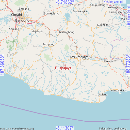
Puspajaya GPS coordinates[2]
7° 24' 59.04" South, 108° 4' 10.92" East
| Map corner | latitude | longitude |
|---|---|---|
| Upper-left | -6.71862°, | 107.36658° |
| Center: | -7.4164°, | 108.0697° |
| Lower-right: | -8.11307°, | 108.77283° |
| Map W x H: | 155×155.1 km | = 96.3×96.4mi |
| max Lat: | 5.88969° ⇑53.7% North |
| Puspajaya: | -7.4164° |
| min Lat: | ⇓46.3% South -10.934° |
| min Long | Puspajaya | max Long |
| 95.1345° | 108.0697° | 140.9419° |
| W 20.9%⇐ | ⇒79.1% E |
Elevation
Elevation of Puspajaya is 522 m = 1713 ft, and this is 292.3 m = 959 ft above average elevation for this country.
| Max E: |
3185 m = 10449 ft | 14.8% |
| Puspajaya | 522 m 1713 ft | |
| Avg. | 229.7 m = 754 ft | |
Min E: |
-1 m = -3 ft | 85.2% |
See also: Indonesia elevation on elevation.city.
Geographical zone
Puspajaya is located in South Torrid zone (between Equator and Tropic of Capricorn). Distance of Equator is 824.6 km =512.4 mi to North.| Distance of | km | miles | from Puspajaya |
|---|---|---|---|
| Equator | 824.6 | 512.4 | to North |
| Tropic Capricorn | 1781.3 | 1106.8 | to South |
| Antarctic Circle | 6576.5 | 4086.4 | to South |
| South Pole | 9182.4 | 5705.7 | to South |


Nearby cities:
15 places around Puspajaya: (largest is in red/bold)
• Bebedahan
5.5 km =3.4 mi,  78°
78°
• Ciawitali
3.7 km =2.3 mi,  346°
346°
• Cikalong
5.2 km =3.2 mi,  202°
202°
• Cikeusal
5.3 km =3.3 mi,  110°
110°
• Cimanggu
2.5 km =1.6 mi,  57°
57°
• Cimaung
3.8 km =2.4 mi,  67°
67°
• Ciwidara
4.9 km =3 mi,  357°
357°
• Deudeul
4.9 km =3 mi,  250°
250°
• Karangsari
3.7 km =2.3 mi,  154°
154°
• Nagrog
5.3 km =3.3 mi,  304°
304°
• Pasirsalam
2.4 km =1.5 mi,  20°
20°
• Puspahiang
2.2 km =1.4 mi,  262°
262°
• Pusparahayu
1.8 km =1.1 mi,  220°
220°
• Sukasukur
4.8 km =3 mi,  7°
7°
• Warungpeuteuy
5 km =3.1 mi,  330°
330°
Sources, notices
• [Note1] Compared only with cities in Indonesia existing in our database
• [Src1] Map data: © OpenStreetMap contributors (CC-BY-SA)
• [Src2] Other city data from geonames.org with taken over terms of usage.
• [Src3] Geographical zone / Annual Mean Temperature by Robert A. Rohde @ Wikipedia
