Pasarkolot geodata
Pasarkolot (West Java) is a seat of a fourth-order administrative division; located in Indonesia in Asia/Jakarta (GMT+7) time zone. In our database, there are 407 cities with bigger population. Compared to other cities in Indonesia, 62.2% of cities are located further ↓South; 78.8% of cities are located further →East and 89.9% of cities have lower elevation than Pasarkolot. Note1


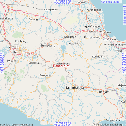
Pasarkolot GPS coordinates[2]
7° 3' 23.4" South, 108° 5' 24" East
| Map corner | latitude | longitude |
|---|---|---|
| Upper-left | -6.35819°, | 107.38688° |
| Center: | -7.0565°, | 108.09° |
| Lower-right: | -7.75376°, | 108.79313° |
| Map W x H: | 155.2×155.2 km | = 96.4×96.4mi |
| max Lat: | 5.88969° ⇑37.8% North |
| Pasarkolot: | -7.0565° |
| min Lat: | ⇓62.2% South -10.934° |
| min Long | Pasarkolot | max Long |
| 95.1345° | 108.09° | 140.9419° |
| W 21.2%⇐ | ⇒78.8% E |
Elevation
Elevation of Pasarkolot is 636 m = 2087 ft, and this is 406.3 m = 1333 ft above average elevation for this country.
| Max E: |
3185 m = 10449 ft | 10.1% |
| Pasarkolot | 636 m 2087 ft | |
| Avg. | 229.7 m = 754 ft | |
Min E: |
-1 m = -3 ft | 89.9% |
See also: Indonesia elevation on elevation.city.
Geographical zone
Pasarkolot is located in South Torrid zone (between Equator and Tropic of Capricorn). Distance of Equator is 784.6 km =487.5 mi to North.| Distance of | km | miles | from Pasarkolot |
|---|---|---|---|
| Equator | 784.6 | 487.5 | to North |
| Tropic Capricorn | 1821.3 | 1131.7 | to South |
| Antarctic Circle | 6616.6 | 4111.4 | to South |
| South Pole | 9222.5 | 5730.6 | to South |


Nearby cities:
15 places around Pasarkolot: (largest is in red/bold)
• Babakan Nyampay
1.2 km =0.7 mi,  343°
343°
• Cibunar
2.7 km =1.7 mi,  295°
295°
• Cipeuyeum
1.1 km =0.7 mi,  186°
186°
• Citalahab
1.4 km =0.9 mi,  207°
207°
• Lewo
4.1 km =2.5 mi,  252°
252°
• Malangbong
0.5 km =0.3 mi, 212°
• Mekarasih
3.3 km =2.1 mi,  352°
352°
• Pangkalan
4.5 km =2.8 mi,  331°
331°
• Pasar
4.5 km =2.8 mi,  165°
165°
• Pasirbaros
2.3 km =1.4 mi, 166°
• Rancamaya
2.7 km =1.7 mi, 327°
• Saar
1.9 km =1.2 mi,  265°
265°
• Sukabatu
3.8 km =2.4 mi,  224°
224°
• Sukamulya
4.6 km =2.9 mi,  198°
198°
• Sukaratu
4.6 km =2.9 mi, 274°
Sources, notices
• [Note1] Compared only with cities in Indonesia existing in our database
• [Src1] Map data: © OpenStreetMap contributors (CC-BY-SA)
• [Src2] Other city data from geonames.org with taken over terms of usage.
• [Src3] Geographical zone / Annual Mean Temperature by Robert A. Rohde @ Wikipedia
