Gununggoong geodata
Gununggoong (West Java) is a seat of a fourth-order administrative division; located in Indonesia in Asia/Jakarta (GMT+7) time zone. In our database, there are 407 cities with bigger population. Compared to other cities in Indonesia, 59.4% of cities are located further ↑North; 76% of cities are located further →East and 70.8% of cities have lower elevation than Gununggoong. Note1


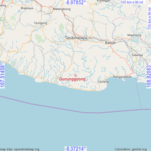
Gununggoong GPS coordinates[2]
7° 40' 33.24" South, 108° 13' 3.72" East
| Map corner | latitude | longitude |
|---|---|---|
| Upper-left | -6.97852°, | 107.51458° |
| Center: | -7.6759°, | 108.2177° |
| Lower-right: | -8.37214°, | 108.92083° |
| Map W x H: | 155×155 km | = 96.3×96.3mi |
| max Lat: | 5.88969° ⇑59.4% North |
| Gununggoong: | -7.6759° |
| min Lat: | ⇓40.6% South -10.934° |
| min Long | Gununggoong | max Long |
| 95.1345° | 108.2177° | 140.9419° |
| W 24%⇐ | ⇒76% E |
Elevation
Elevation of Gununggoong is 303 m = 994 ft, and this is 73.3 m = 240 ft above average elevation for this country.
| Max E: |
3185 m = 10449 ft | 29.2% |
| Gununggoong | 303 m 994 ft | |
| Avg. | 229.7 m = 754 ft | |
Min E: |
-1 m = -3 ft | 70.8% |
See also: Indonesia elevation on elevation.city.
Geographical zone
Gununggoong is located in South Torrid zone (between Equator and Tropic of Capricorn). Distance of Equator is 853.5 km =530.3 mi to North.| Distance of | km | miles | from Gununggoong |
|---|---|---|---|
| Equator | 853.5 | 530.3 | to North |
| Tropic Capricorn | 1752.4 | 1088.9 | to South |
| Antarctic Circle | 6547.7 | 4068.6 | to South |
| South Pole | 9153.6 | 5687.8 | to South |


Nearby cities:
15 places around Gununggoong: (largest is in red/bold)
• Bantar
6.1 km =3.8 mi,  349°
349°
• Barengkok
6.3 km =3.9 mi,  226°
226°
• Bojongsari
6 km =3.7 mi,  94°
94°
• Cibatu
5.2 km =3.2 mi,  338°
338°
• Cibatuireng
6.5 km =4 mi,  313°
313°
• Cibeber
4.3 km =2.7 mi,  212°
212°
• Cibongas
6.3 km =3.9 mi,  72°
72°
• Cibunter
7 km =4.3 mi,  182°
182°
• Cidadali
4.2 km =2.6 mi,  193°
193°
• Cigembor
7.3 km =4.5 mi, 335°
• Cikatomas
7.6 km =4.7 mi,  36°
36°
• Citamiang
4.9 km =3 mi,  26°
26°
• Jatiwangi
2 km =1.2 mi, 33°
• Pakemitan Dua
7.3 km =4.5 mi, 35°
• Singkir
7.4 km =4.6 mi,  216°
216°
Sources, notices
• [Note1] Compared only with cities in Indonesia existing in our database
• [Src1] Map data: © OpenStreetMap contributors (CC-BY-SA)
• [Src2] Other city data from geonames.org with taken over terms of usage.
• [Src3] Geographical zone / Annual Mean Temperature by Robert A. Rohde @ Wikipedia
