Barengkok geodata
Barengkok (West Java) is a seat of a fourth-order administrative division; located in Indonesia in Asia/Jakarta (GMT+7) time zone. In our database, there are 407 cities with bigger population. Compared to other cities in Indonesia, 59.8% of cities are located further ↑North; 77.2% of cities are located further →East and 60.2% of cities have lower elevation than Barengkok. Note1


Barengkok GPS coordinates[2]
7° 42' 54.72" South, 108° 10' 34.32" East
| Map corner | latitude | longitude |
|---|---|---|
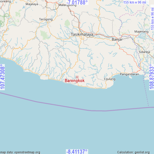
| Upper-left | -7.01788°, | 107.47308° |
| Center: | -7.7152°, | 108.1762° |
| Lower-right: | -8.41137°, | 108.87933° |
| Map W x H: | 154.9×154.9 km | = 96.3×96.3mi |
| max Lat: | 5.88969° ⇑59.8% North |
| Barengkok: | -7.7152° |
| min Lat: | ⇓40.2% South -10.934° |
| min Long | Barengkok | max Long |
| 95.1345° | 108.1762° | 140.9419° |
| W 22.8%⇐ | ⇒77.2% E |
Elevation
Elevation of Barengkok is 166 m = 545 ft, and this is 63.7 m = 209 ft below average elevation for this country.
| Max E: |
3185 m = 10449 ft | 39.8% |
| Avg. | 229.7 m = 754 ft | |
| Barengkok | 166 m = 545 ft | |
Min E: |
-1 m = -3 ft | 60.2% |
See also: Indonesia elevation on elevation.city.
Geographical zone
Barengkok is located in South Torrid zone (between Equator and Tropic of Capricorn). Distance of Equator is 857.8 km =533 mi to North.| Distance of | km | miles | from Barengkok |
|---|---|---|---|
| Equator | 857.8 | 533 | to North |
| Tropic Capricorn | 1748.1 | 1086.2 | to South |
| Antarctic Circle | 6543.3 | 4065.8 | to South |
| South Pole | 9149.2 | 5685 | to South |


Nearby cities:
15 places around Barengkok: (largest is in red/bold)
• Ciawi
8.1 km =5 mi,  317°
317°
• Cibeber
2.3 km =1.4 mi,  71°
71°
• Cibunter
5 km =3.1 mi,  121°
121°
• Cidadali
3.6 km =2.2 mi,  85°
85°
• Cidadap
7.4 km =4.6 mi,  211°
211°
• Cikalong
5.3 km =3.3 mi,  184°
184°
• Cikancra
5.7 km =3.5 mi,  137°
137°
• Cilangla
7.5 km =4.7 mi,  306°
306°
• Gununggoong
6.3 km =3.9 mi,  46°
46°
• Kujang
5.3 km =3.3 mi,  233°
233°
• Nangerang
7 km =4.3 mi,  130°
130°
• Petakan
5.9 km =3.7 mi,  297°
297°
• Singkir
1.6 km =1 mi,  172°
172°
• Sukahaji Satu
6.7 km =4.2 mi, 171°
• Tonjongsari
2.6 km =1.6 mi,  164°
164°
Sources, notices
• [Note1] Compared only with cities in Indonesia existing in our database
• [Src1] Map data: © OpenStreetMap contributors (CC-BY-SA)
• [Src2] Other city data from geonames.org with taken over terms of usage.
• [Src3] Geographical zone / Annual Mean Temperature by Robert A. Rohde @ Wikipedia
