Gereba geodata
Gereba (West Java) is a seat of a fourth-order administrative division; located in Indonesia in Asia/Jakarta (GMT+7) time zone. In our database, there are 407 cities with bigger population. Compared to other cities in Indonesia, 56.4% of cities are located further ↓South; 77.7% of cities are located further →East and 87.2% of cities have lower elevation than Gereba. Note1


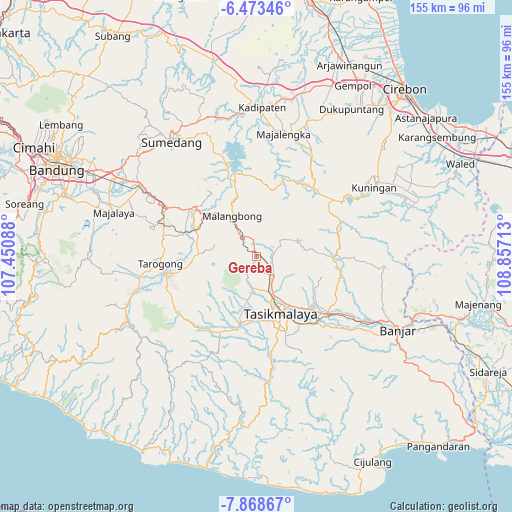
Gereba GPS coordinates[2]
7° 10' 17.76" South, 108° 9' 14.4" East
| Map corner | latitude | longitude |
|---|---|---|
| Upper-left | -6.47346°, | 107.45088° |
| Center: | -7.1716°, | 108.154° |
| Lower-right: | -7.86867°, | 108.85713° |
| Map W x H: | 155.1×155.1 km | = 96.4×96.4mi |
| max Lat: | 5.88969° ⇑43.6% North |
| Gereba: | -7.1716° |
| min Lat: | ⇓56.4% South -10.934° |
| min Long | Gereba | max Long |
| 95.1345° | 108.154° | 140.9419° |
| W 22.3%⇐ | ⇒77.7% E |
Elevation
Elevation of Gereba is 561 m = 1841 ft, and this is 331.3 m = 1087 ft above average elevation for this country.
| Max E: |
3185 m = 10449 ft | 12.8% |
| Gereba | 561 m 1841 ft | |
| Avg. | 229.7 m = 754 ft | |
Min E: |
-1 m = -3 ft | 87.2% |
See also: Indonesia elevation on elevation.city.
Geographical zone
Gereba is located in South Torrid zone (between Equator and Tropic of Capricorn). Distance of Equator is 797.4 km =495.5 mi to North.| Distance of | km | miles | from Gereba |
|---|---|---|---|
| Equator | 797.4 | 495.5 | to North |
| Tropic Capricorn | 1808.5 | 1123.7 | to South |
| Antarctic Circle | 6603.8 | 4103.4 | to South |
| South Pole | 9209.7 | 5722.6 | to South |


Nearby cities:
15 places around Gereba: (largest is in red/bold)
• Anto
2.6 km =1.6 mi,  277°
277°
• Asem
2 km =1.2 mi,  324°
324°
• Bugel
3 km =1.9 mi,  242°
242°
• Ciomas
1.8 km =1.1 mi,  114°
114°
• Cipanjang
2.1 km =1.3 mi,  50°
50°
• Condong
3 km =1.9 mi,  172°
172°
• Gombong
3 km =1.9 mi,  221°
221°
• Kaum Kaler
1.6 km =1 mi,  333°
333°
• Kudang
0.9 km =0.6 mi,  344°
344°
• Pakemitan
1.7 km =1.1 mi, 342°
• Rancakuya
3.1 km =1.9 mi,  345°
345°
• Sangiangteras
1.6 km =1 mi,  179°
179°
• Sukamenak
3 km =1.9 mi,  84°
84°
• Sukasenang
1.4 km =0.9 mi, 82°
• Timbulsari
2.3 km =1.4 mi,  188°
188°
Sources, notices
• [Note1] Compared only with cities in Indonesia existing in our database
• [Src1] Map data: © OpenStreetMap contributors (CC-BY-SA)
• [Src2] Other city data from geonames.org with taken over terms of usage.
• [Src3] Geographical zone / Annual Mean Temperature by Robert A. Rohde @ Wikipedia
