Anto geodata
Anto (West Java) is a seat of a fourth-order administrative division; located in Indonesia in Asia/Jakarta (GMT+7) time zone. In our database, there are 407 cities with bigger population. Compared to other cities in Indonesia, 56.5% of cities are located further ↓South; 78.2% of cities are located further →East and 89.1% of cities have lower elevation than Anto. Note1


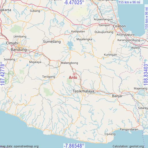
Anto GPS coordinates[2]
7° 10' 6.24" South, 108° 7' 51.24" East
| Map corner | latitude | longitude |
|---|---|---|
| Upper-left | -6.47025°, | 107.42778° |
| Center: | -7.1684°, | 108.1309° |
| Lower-right: | -7.86548°, | 108.83403° |
| Map W x H: | 155.1×155.1 km | = 96.4×96.4mi |
| max Lat: | 5.88969° ⇑43.5% North |
| Anto: | -7.1684° |
| min Lat: | ⇓56.5% South -10.934° |
| min Long | Anto | max Long |
| 95.1345° | 108.1309° | 140.9419° |
| W 21.8%⇐ | ⇒78.2% E |
Elevation
Elevation of Anto is 611 m = 2005 ft, and this is 381.3 m = 1251 ft above average elevation for this country.
| Max E: |
3185 m = 10449 ft | 10.9% |
| Anto | 611 m 2005 ft | |
| Avg. | 229.7 m = 754 ft | |
Min E: |
-1 m = -3 ft | 89.1% |
See also: Indonesia elevation on elevation.city.
Geographical zone
Anto is located in South Torrid zone (between Equator and Tropic of Capricorn). Distance of Equator is 797.1 km =495.3 mi to North.| Distance of | km | miles | from Anto |
|---|---|---|---|
| Equator | 797.1 | 495.3 | to North |
| Tropic Capricorn | 1808.9 | 1124 | to South |
| Antarctic Circle | 6604.1 | 4103.6 | to South |
| South Pole | 9210 | 5722.8 | to South |


Nearby cities:
15 places around Anto: (largest is in red/bold)
• Asem
1.9 km =1.2 mi,  46°
46°
• Bugel
1.7 km =1.1 mi,  184°
184°
• Cijangkar
3.3 km =2.1 mi,  23°
23°
• Gereba
2.6 km =1.6 mi,  97°
97°
• Gombong
2.6 km =1.6 mi,  167°
167°
• Kaum Kaler
2.1 km =1.3 mi,  60°
60°
• Kertamukti
3.2 km =2 mi,  197°
197°
• Kiarajangkung
3.5 km =2.2 mi, 183°
• Kudang
2.4 km =1.5 mi,  78°
78°
• Medangdatar
1.3 km =0.8 mi,  332°
332°
• Pakemitan
2.4 km =1.5 mi, 58°
• Rancakuya
3.2 km =2 mi,  34°
34°
• Sangiangteras
3.2 km =2 mi,  127°
127°
• Sindangtamu
3.4 km =2.1 mi, 34°
• Timbulsari
3.5 km =2.2 mi,  140°
140°
Sources, notices
• [Note1] Compared only with cities in Indonesia existing in our database
• [Src1] Map data: © OpenStreetMap contributors (CC-BY-SA)
• [Src2] Other city data from geonames.org with taken over terms of usage.
• [Src3] Geographical zone / Annual Mean Temperature by Robert A. Rohde @ Wikipedia
