Sariwangi geodata
Sariwangi (West Java) is a seat of a fourth-order administrative division; located in Indonesia in Asia/Jakarta (GMT+7) time zone. In our database, there are 407 cities with bigger population. Compared to other cities in Indonesia, 53.3% of cities are located further ↓South; 77.1% of cities are located further →East and 82.5% of cities have lower elevation than Sariwangi. Note1


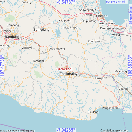
Sariwangi GPS coordinates[2]
7° 14' 45.24" South, 108° 10' 49.8" East
| Map corner | latitude | longitude |
|---|---|---|
| Upper-left | -6.54787°, | 107.47738° |
| Center: | -7.2459°, | 108.1805° |
| Lower-right: | -7.94285°, | 108.88363° |
| Map W x H: | 155.1×155.1 km | = 96.4×96.4mi |
| max Lat: | 5.88969° ⇑46.7% North |
| Sariwangi: | -7.2459° |
| min Lat: | ⇓53.3% South -10.934° |
| min Long | Sariwangi | max Long |
| 95.1345° | 108.1805° | 140.9419° |
| W 22.9%⇐ | ⇒77.1% E |
Elevation
Elevation of Sariwangi is 470 m = 1542 ft, and this is 240.3 m = 788 ft above average elevation for this country.
| Max E: |
3185 m = 10449 ft | 17.5% |
| Sariwangi | 470 m 1542 ft | |
| Avg. | 229.7 m = 754 ft | |
Min E: |
-1 m = -3 ft | 82.5% |
See also: Indonesia elevation on elevation.city.
Geographical zone
Sariwangi is located in South Torrid zone (between Equator and Tropic of Capricorn). Distance of Equator is 805.7 km =500.6 mi to North.| Distance of | km | miles | from Sariwangi |
|---|---|---|---|
| Equator | 805.7 | 500.6 | to North |
| Tropic Capricorn | 1800.3 | 1118.7 | to South |
| Antarctic Circle | 6595.5 | 4098.3 | to South |
| South Pole | 9201.4 | 5717.5 | to South |


Nearby cities:
15 places around Sariwangi: (largest is in red/bold)
• Ciburuyhilir
2.5 km =1.6 mi,  187°
187°
• Cigebay
2.9 km =1.8 mi,  315°
315°
• Cijulang
2.5 km =1.6 mi,  133°
133°
• Cikadu
2.5 km =1.6 mi,  343°
343°
• Dawagung
1.5 km =0.9 mi,  34°
34°
• Jantake
2.7 km =1.7 mi,  266°
266°
• Karangmulya
2.6 km =1.6 mi,  229°
229°
• Kebonbencoy
1.1 km =0.7 mi,  137°
137°
• Nanggela
1.8 km =1.1 mi,  74°
74°
• Neundeut
1.9 km =1.2 mi,  211°
211°
• Pagendingan
2.3 km =1.4 mi,  163°
163°
• Pasarlama
2.8 km =1.7 mi,  21°
21°
• Rajapolah
2.9 km =1.8 mi, 19°
• Sirnarasa
2.3 km =1.4 mi,  305°
305°
• Sukasetia
1.7 km =1.1 mi,  98°
98°
Sources, notices
• [Note1] Compared only with cities in Indonesia existing in our database
• [Src1] Map data: © OpenStreetMap contributors (CC-BY-SA)
• [Src2] Other city data from geonames.org with taken over terms of usage.
• [Src3] Geographical zone / Annual Mean Temperature by Robert A. Rohde @ Wikipedia
