Rajapolah geodata
Rajapolah (West Java) is a seat of a third-order administrative division; located in Indonesia in Asia/Jakarta (GMT+7) time zone. With population of 39,840 people, there are 271 cities with bigger population in this country. Compared to other cities in Indonesia, 54.1% of cities are located further ↓South; 76.8% of cities are located further →East and 82.3% of cities have lower elevation than Rajapolah. Note1


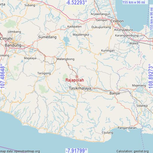
Rajapolah GPS coordinates[2]
7° 13' 15.6" South, 108° 11' 22.56" East
| Map corner | latitude | longitude |
|---|---|---|
| Upper-left | -6.52293°, | 107.48648° |
| Center: | -7.221°, | 108.1896° |
| Lower-right: | -7.91799°, | 108.89273° |
| Map W x H: | 155.1×155.1 km | = 96.4×96.4mi |
| max Lat: | 5.88969° ⇑45.9% North |
| Rajapolah: | -7.221° |
| min Lat: | ⇓54.1% South -10.934° |
| min Long | Rajapolah | max Long |
| 95.1345° | 108.1896° | 140.9419° |
| W 23.2%⇐ | ⇒76.8% E |
Elevation
Elevation of Rajapolah is 467 m = 1532 ft, and this is 237.3 m = 779 ft above average elevation for this country.
| Max E: |
3185 m = 10449 ft | 17.7% |
| Rajapolah | 467 m 1532 ft | |
| Avg. | 229.7 m = 754 ft | |
Min E: |
-1 m = -3 ft | 82.3% |
See also: Indonesia elevation on elevation.city.
Geographical zone
Rajapolah is located in South Torrid zone (between Equator and Tropic of Capricorn). Distance of Equator is 802.9 km =498.9 mi to North.| Distance of | km | miles | from Rajapolah |
|---|---|---|---|
| Equator | 802.9 | 498.9 | to North |
| Tropic Capricorn | 1803 | 1120.3 | to South |
| Antarctic Circle | 6598.3 | 4100 | to South |
| South Pole | 9204.2 | 5719.2 | to South |


Nearby cities:
15 places around Rajapolah: (largest is in red/bold)
• Cihateup
2.3 km =1.4 mi,  290°
290°
• Cihaurbeuti
1.3 km =0.8 mi,  101°
101°
• Ciinjuk
1.6 km =1 mi,  348°
348°
• Cikadu
1.8 km =1.1 mi,  259°
259°
• Dawagung
1.5 km =0.9 mi,  185°
185°
• Dusun Tengah Cihaurbeuti
1.5 km =0.9 mi,  106°
106°
• Kampungdesa Pamokolan
2.9 km =1.8 mi,  23°
23°
• Margasari
0.2 km =0.1 mi, 101°
• Nanggela
2.4 km =1.5 mi,  162°
162°
• Padamulya
2.5 km =1.6 mi,  34°
34°
• Pasarlama
0.2 km =0.1 mi,  173°
173°
• Pasirtamiang
2.5 km =1.6 mi,  64°
64°
• Sariwangi
2.9 km =1.8 mi,  199°
199°
• Singabarong
2.8 km =1.7 mi,  334°
334°
• Sukaraja
1.8 km =1.1 mi,  306°
306°
Sources, notices
• [Note1] Compared only with cities in Indonesia existing in our database
• [Src1] Map data: © OpenStreetMap contributors (CC-BY-SA)
• [Src2] Other city data from geonames.org with taken over terms of usage.
• [Src3] Geographical zone / Annual Mean Temperature by Robert A. Rohde @ Wikipedia
