Warung Kulon geodata
Warung Kulon (West Java) is a seat of a fourth-order administrative division; located in Indonesia in Asia/Jakarta (GMT+7) time zone. In our database, there are 407 cities with bigger population. Compared to other cities in Indonesia, 50.4% of cities are located further ↓South; 74.7% of cities are located further →East and 70.3% of cities have lower elevation than Warung Kulon. Note1


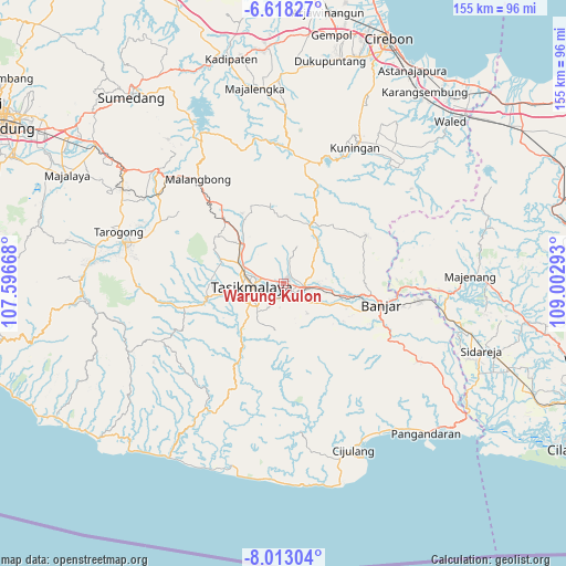
Warung Kulon GPS coordinates[2]
7° 18' 58.32" South, 108° 17' 59.28" East
| Map corner | latitude | longitude |
|---|---|---|
| Upper-left | -6.61827°, | 107.59668° |
| Center: | -7.3162°, | 108.2998° |
| Lower-right: | -8.01304°, | 109.00293° |
| Map W x H: | 155.1×155.1 km | = 96.4×96.4mi |
| max Lat: | 5.88969° ⇑49.6% North |
| Warung Kulon: | -7.3162° |
| min Lat: | ⇓50.4% South -10.934° |
| min Long | Warung Kulon | max Long |
| 95.1345° | 108.2998° | 140.9419° |
| W 25.3%⇐ | ⇒74.7% E |
Elevation
Elevation of Warung Kulon is 296 m = 971 ft, and this is 66.3 m = 218 ft above average elevation for this country.
| Max E: |
3185 m = 10449 ft | 29.7% |
| Warung Kulon | 296 m 971 ft | |
| Avg. | 229.7 m = 754 ft | |
Min E: |
-1 m = -3 ft | 70.3% |
See also: Indonesia elevation on elevation.city.
Geographical zone
Warung Kulon is located in South Torrid zone (between Equator and Tropic of Capricorn). Distance of Equator is 813.5 km =505.5 mi to North.| Distance of | km | miles | from Warung Kulon |
|---|---|---|---|
| Equator | 813.5 | 505.5 | to North |
| Tropic Capricorn | 1792.4 | 1113.7 | to South |
| Antarctic Circle | 6587.7 | 4093.4 | to South |
| South Pole | 9193.6 | 5712.6 | to South |


Nearby cities:
15 places around Warung Kulon: (largest is in red/bold)
• Bunirasa
3.7 km =2.3 mi,  123°
123°
• Cibeureum
3.1 km =1.9 mi,  103°
103°
• Cibodas
2.9 km =1.8 mi,  300°
300°
• Cikoneng
3.2 km =2 mi,  278°
278°
• Cisadap
1 km =0.6 mi,  48°
48°
• Colendra
1.4 km =0.9 mi,  333°
333°
• Desa Cimari
1.4 km =0.9 mi,  289°
289°
• Desa Gegempalan
1.6 km =1 mi,  220°
220°
• Desa Sukajadi
3.4 km =2.1 mi,  76°
76°
• Gerempay
2.7 km =1.7 mi,  207°
207°
• Linggamanik
2.2 km =1.4 mi, 124°
• Pasar Sabtu
3.7 km =2.3 mi, 280°
• Pasirjaya
3.6 km =2.2 mi,  254°
254°
• Tangsi
3.6 km =2.2 mi,  165°
165°
• Warung Wetan
0.8 km =0.5 mi, 99°
Sources, notices
• [Note1] Compared only with cities in Indonesia existing in our database
• [Src1] Map data: © OpenStreetMap contributors (CC-BY-SA)
• [Src2] Other city data from geonames.org with taken over terms of usage.
• [Src3] Geographical zone / Annual Mean Temperature by Robert A. Rohde @ Wikipedia
