Linggamanik geodata
Linggamanik (West Java) is a seat of a fourth-order administrative division; located in Indonesia in Asia/Jakarta (GMT+7) time zone. In our database, there are 407 cities with bigger population. Compared to other cities in Indonesia, 50.2% of cities are located further ↑North; 74.4% of cities are located further →East and 67.7% of cities have lower elevation than Linggamanik. Note1


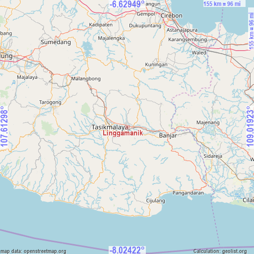
Linggamanik GPS coordinates[2]
7° 19' 38.64" South, 108° 18' 57.96" East
| Map corner | latitude | longitude |
|---|---|---|
| Upper-left | -6.62949°, | 107.61298° |
| Center: | -7.3274°, | 108.3161° |
| Lower-right: | -8.02422°, | 109.01923° |
| Map W x H: | 155.1×155.1 km | = 96.4×96.4mi |
| max Lat: | 5.88969° ⇑50.2% North |
| Linggamanik: | -7.3274° |
| min Lat: | ⇓49.8% South -10.934° |
| min Long | Linggamanik | max Long |
| 95.1345° | 108.3161° | 140.9419° |
| W 25.6%⇐ | ⇒74.4% E |
Elevation
Elevation of Linggamanik is 260 m = 853 ft, and this is 30.3 m = 99 ft above average elevation for this country.
| Max E: |
3185 m = 10449 ft | 32.3% |
| Linggamanik | 260 m 853 ft | |
| Avg. | 229.7 m = 754 ft | |
Min E: |
-1 m = -3 ft | 67.7% |
See also: Indonesia elevation on elevation.city.
Geographical zone
Linggamanik is located in South Torrid zone (between Equator and Tropic of Capricorn). Distance of Equator is 814.7 km =506.2 mi to North.| Distance of | km | miles | from Linggamanik |
|---|---|---|---|
| Equator | 814.7 | 506.2 | to North |
| Tropic Capricorn | 1791.2 | 1113 | to South |
| Antarctic Circle | 6586.4 | 4092.6 | to South |
| South Pole | 9192.3 | 5711.8 | to South |


Nearby cities:
15 places around Linggamanik: (largest is in red/bold)
• Bunirasa
1.5 km =0.9 mi,  120°
120°
• Cibeureum
1.3 km =0.8 mi,  65°
65°
• Ciherang
2.6 km =1.6 mi,  112°
112°
• Cisadap
2.2 km =1.4 mi,  331°
331°
• Colendra
3.5 km =2.2 mi,  315°
315°
• Desa Cimari
3.5 km =2.2 mi,  298°
298°
• Desa Gegempalan
2.8 km =1.7 mi,  271°
271°
• Desa Sukajadi
2.5 km =1.6 mi,  35°
35°
• Gerempay
3.3 km =2.1 mi,  249°
249°
• Karangsari
3.4 km =2.1 mi,  80°
80°
• Kreteg
2.8 km =1.7 mi,  47°
47°
• Manonjaya
2.7 km =1.7 mi,  197°
197°
• Tangsi
2.5 km =1.6 mi, 201°
• Warung Kulon
2.2 km =1.4 mi, 304°
• Warung Wetan
1.5 km =0.9 mi, 317°
Sources, notices
• [Note1] Compared only with cities in Indonesia existing in our database
• [Src1] Map data: © OpenStreetMap contributors (CC-BY-SA)
• [Src2] Other city data from geonames.org with taken over terms of usage.
• [Src3] Geographical zone / Annual Mean Temperature by Robert A. Rohde @ Wikipedia
