Lumbung Kidul geodata
Lumbung Kidul (West Java) is a seat of a fourth-order administrative division; located in Indonesia in Asia/Jakarta (GMT+7) time zone. In our database, there are 407 cities with bigger population. Compared to other cities in Indonesia, 56.9% of cities are located further ↓South; 74.2% of cities are located further →East and 83.8% of cities have lower elevation than Lumbung Kidul. Note1


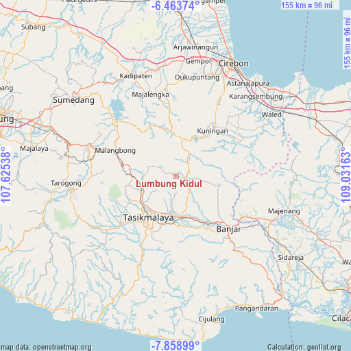
Lumbung Kidul GPS coordinates[2]
7° 9' 42.84" South, 108° 19' 42.6" East
| Map corner | latitude | longitude |
|---|---|---|
| Upper-left | -6.46374°, | 107.62538° |
| Center: | -7.1619°, | 108.3285° |
| Lower-right: | -7.85899°, | 109.03163° |
| Map W x H: | 155.1×155.1 km | = 96.4×96.4mi |
| max Lat: | 5.88969° ⇑43.1% North |
| Lumbung Kidul: | -7.1619° |
| min Lat: | ⇓56.9% South -10.934° |
| min Long | Lumbung Kidul | max Long |
| 95.1345° | 108.3285° | 140.9419° |
| W 25.8%⇐ | ⇒74.2% E |
Elevation
Elevation of Lumbung Kidul is 496 m = 1627 ft, and this is 266.3 m = 874 ft above average elevation for this country.
| Max E: |
3185 m = 10449 ft | 16.2% |
| Lumbung Kidul | 496 m 1627 ft | |
| Avg. | 229.7 m = 754 ft | |
Min E: |
-1 m = -3 ft | 83.8% |
See also: Indonesia elevation on elevation.city.
Geographical zone
Lumbung Kidul is located in South Torrid zone (between Equator and Tropic of Capricorn). Distance of Equator is 796.3 km =494.8 mi to North.| Distance of | km | miles | from Lumbung Kidul |
|---|---|---|---|
| Equator | 796.3 | 494.8 | to North |
| Tropic Capricorn | 1809.6 | 1124.4 | to South |
| Antarctic Circle | 6604.8 | 4104 | to South |
| South Pole | 9210.7 | 5723.3 | to South |


Nearby cities:
15 places around Lumbung Kidul: (largest is in red/bold)
• Awiluar
1.2 km =0.7 mi,  54°
54°
• Babantar
1.2 km =0.7 mi,  100°
100°
• Bungursari
0.8 km =0.5 mi,  5°
5°
• Cikoneng
2.3 km =1.4 mi,  135°
135°
• Cilongo
3.7 km =2.3 mi,  133°
133°
• Ciomas
4.6 km =2.9 mi,  282°
282°
• Citeureup
2.7 km =1.7 mi,  81°
81°
• Karoya
3 km =1.9 mi,  296°
296°
• Kertaharja
2.2 km =1.4 mi,  192°
192°
• Kertanagara
3.5 km =2.2 mi,  146°
146°
• Rawa Satu
1.3 km =0.8 mi,  288°
288°
• Singgugu
3.8 km =2.4 mi, 49°
• Sukaraharja
0.7 km =0.4 mi,  196°
196°
• Tanjungjaya
2.4 km =1.5 mi,  108°
108°
• Winduraja
4.3 km =2.7 mi, 113°
Sources, notices
• [Note1] Compared only with cities in Indonesia existing in our database
• [Src1] Map data: © OpenStreetMap contributors (CC-BY-SA)
• [Src2] Other city data from geonames.org with taken over terms of usage.
• [Src3] Geographical zone / Annual Mean Temperature by Robert A. Rohde @ Wikipedia
