Singgugu geodata
Singgugu (West Java) is a seat of a fourth-order administrative division; located in Indonesia in Asia/Jakarta (GMT+7) time zone. In our database, there are 407 cities with bigger population. Compared to other cities in Indonesia, 58.1% of cities are located further ↓South; 73.7% of cities are located further →East and 84.5% of cities have lower elevation than Singgugu. Note1


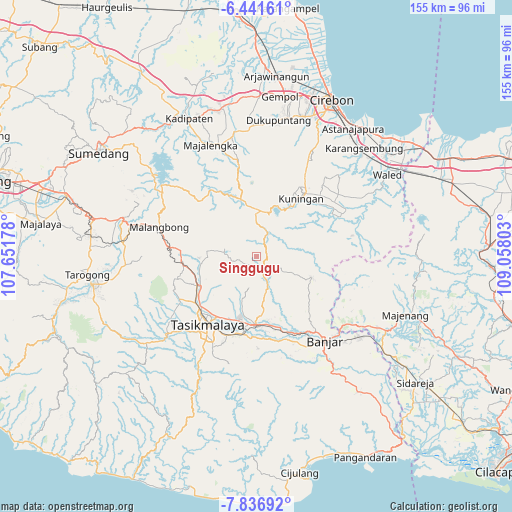
Singgugu GPS coordinates[2]
7° 8' 23.28" South, 108° 21' 17.64" East
| Map corner | latitude | longitude |
|---|---|---|
| Upper-left | -6.44161°, | 107.65178° |
| Center: | -7.1398°, | 108.3549° |
| Lower-right: | -7.83692°, | 109.05803° |
| Map W x H: | 155.1×155.1 km | = 96.4×96.4mi |
| max Lat: | 5.88969° ⇑41.9% North |
| Singgugu: | -7.1398° |
| min Lat: | ⇓58.1% South -10.934° |
| min Long | Singgugu | max Long |
| 95.1345° | 108.3549° | 140.9419° |
| W 26.3%⇐ | ⇒73.7% E |
Elevation
Elevation of Singgugu is 509 m = 1670 ft, and this is 279.3 m = 916 ft above average elevation for this country.
| Max E: |
3185 m = 10449 ft | 15.5% |
| Singgugu | 509 m 1670 ft | |
| Avg. | 229.7 m = 754 ft | |
Min E: |
-1 m = -3 ft | 84.5% |
See also: Indonesia elevation on elevation.city.
Geographical zone
Singgugu is located in South Torrid zone (between Equator and Tropic of Capricorn). Distance of Equator is 793.9 km =493.3 mi to North.| Distance of | km | miles | from Singgugu |
|---|---|---|---|
| Equator | 793.9 | 493.3 | to North |
| Tropic Capricorn | 1812 | 1125.9 | to South |
| Antarctic Circle | 6607.3 | 4105.6 | to South |
| South Pole | 9213.2 | 5724.8 | to South |


Nearby cities:
15 places around Singgugu: (largest is in red/bold)
• Awiluar
2.6 km =1.6 mi,  227°
227°
• Babantar
3.2 km =2 mi,  212°
212°
• Bungursari
3.3 km =2.1 mi,  239°
239°
• Cikoneng
4.3 km =2.7 mi,  198°
198°
• Citeureup
2 km =1.2 mi,  186°
186°
• Legok Satu
3.3 km =2.1 mi,  9°
9°
• Lumbung Kidul
3.8 km =2.4 mi, 229°
• Madura
2.8 km =1.7 mi,  108°
108°
• Panawangan
3.8 km =2.4 mi,  50°
50°
• Rawa Satu
4.6 km =2.9 mi, 243°
• Sadewata
3.3 km =2.1 mi,  311°
311°
• Sagalaherang
4.9 km =3 mi,  63°
63°
• Sukaraharja
4.4 km =2.7 mi,  224°
224°
• Tanjungjaya
3.3 km =2.1 mi, 190°
• Winduraja
4.3 km =2.7 mi,  166°
166°
Sources, notices
• [Note1] Compared only with cities in Indonesia existing in our database
• [Src1] Map data: © OpenStreetMap contributors (CC-BY-SA)
• [Src2] Other city data from geonames.org with taken over terms of usage.
• [Src3] Geographical zone / Annual Mean Temperature by Robert A. Rohde @ Wikipedia
