Citotok geodata
Citotok (West Java) is a seat of a fourth-order administrative division; located in Indonesia in Asia/Jakarta (GMT+7) time zone. In our database, there are 407 cities with bigger population. Compared to other cities in Indonesia, 61% of cities are located further ↑North; 72.9% of cities are located further →East and 86.4% of cities have higher elevation than Citotok. Note1


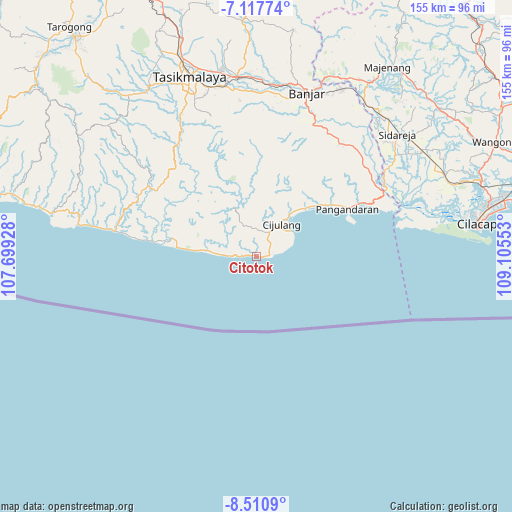
Citotok GPS coordinates[2]
7° 48' 53.64" South, 108° 24' 8.64" East
| Map corner | latitude | longitude |
|---|---|---|
| Upper-left | -7.11774°, | 107.69928° |
| Center: | -7.8149°, | 108.4024° |
| Lower-right: | -8.5109°, | 109.10553° |
| Map W x H: | 154.9×154.9 km | = 96.3×96.3mi |
| max Lat: | 5.88969° ⇑61% North |
| Citotok: | -7.8149° |
| min Lat: | ⇓39% South -10.934° |
| min Long | Citotok | max Long |
| 95.1345° | 108.4024° | 140.9419° |
| W 27.1%⇐ | ⇒72.9% E |
Elevation
Elevation of Citotok is 13 m = 43 ft, and this is 216.7 m = 711 ft below average elevation for this country.
| Max E: |
3185 m = 10449 ft | 86.4% |
| Avg. | 229.7 m = 754 ft | |
| Citotok | 13 m = 43 ft | |
Min E: |
-1 m = -3 ft | 13.6% |
See also: Indonesia elevation on elevation.city.
Geographical zone
Citotok is located in South Torrid zone (between Equator and Tropic of Capricorn). Distance of Equator is 868.9 km =539.9 mi to North.| Distance of | km | miles | from Citotok |
|---|---|---|---|
| Equator | 868.9 | 539.9 | to North |
| Tropic Capricorn | 1737 | 1079.3 | to South |
| Antarctic Circle | 6532.2 | 4058.9 | to South |
| South Pole | 9138.1 | 5678.2 | to South |


Nearby cities:
15 places around Citotok: (largest is in red/bold)
• Babakan
8.1 km =5 mi,  53°
53°
• Banjarwaru
4.7 km =2.9 mi,  330°
330°
• Bulakgebang
8 km =5 mi,  3°
3°
• Cijulang
12.5 km =7.8 mi,  38°
38°
• Cikijing
11.3 km =7 mi,  335°
335°
• Cimerak
8.2 km =5.1 mi,  30°
30°
• Cireuma
3.9 km =2.4 mi,  272°
272°
• Gadog
4.6 km =2.9 mi,  59°
59°
• Kalapagenep
12.1 km =7.5 mi, 273°
• Karanganyar
7.3 km =4.5 mi,  289°
289°
• Mandala
11.4 km =7.1 mi, 43°
• Purwosari
11.7 km =7.3 mi,  320°
320°
• Sindangsari
4.1 km =2.5 mi,  83°
83°
• Sukamenak
9.5 km =5.9 mi, 273°
• Tenjolaya
12.1 km =7.5 mi,  23°
23°
Sources, notices
• [Note1] Compared only with cities in Indonesia existing in our database
• [Src1] Map data: © OpenStreetMap contributors (CC-BY-SA)
• [Src2] Other city data from geonames.org with taken over terms of usage.
• [Src3] Geographical zone / Annual Mean Temperature by Robert A. Rohde @ Wikipedia
