Limusnunggal geodata
Limusnunggal (West Java) is a seat of a third-order administrative division; located in Indonesia in Asia/Jakarta (GMT+7) time zone. In our database, there are 407 cities with bigger population. Compared to other cities in Indonesia, 56% of cities are located further ↑North; 72.9% of cities are located further →East and 86.1% of cities have lower elevation than Limusnunggal. Note1


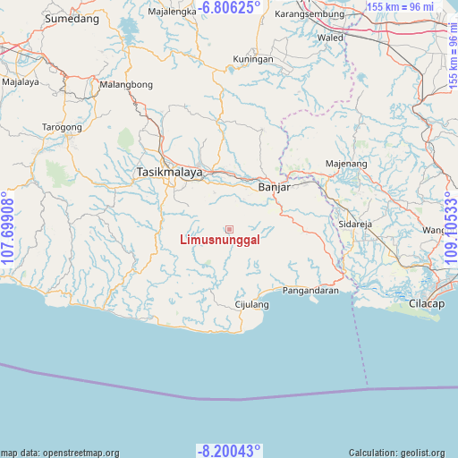
Limusnunggal GPS coordinates[2]
7° 30' 14.04" South, 108° 24' 7.92" East
| Map corner | latitude | longitude |
|---|---|---|
| Upper-left | -6.80625°, | 107.69908° |
| Center: | -7.5039°, | 108.4022° |
| Lower-right: | -8.20043°, | 109.10533° |
| Map W x H: | 155×155 km | = 96.3×96.3mi |
| max Lat: | 5.88969° ⇑56% North |
| Limusnunggal: | -7.5039° |
| min Lat: | ⇓44% South -10.934° |
| min Long | Limusnunggal | max Long |
| 95.1345° | 108.4022° | 140.9419° |
| W 27.1%⇐ | ⇒72.9% E |
Elevation
Elevation of Limusnunggal is 538 m = 1765 ft, and this is 308.3 m = 1011 ft above average elevation for this country.
| Max E: |
3185 m = 10449 ft | 13.9% |
| Limusnunggal | 538 m 1765 ft | |
| Avg. | 229.7 m = 754 ft | |
Min E: |
-1 m = -3 ft | 86.1% |
See also: Indonesia elevation on elevation.city.
Geographical zone
Limusnunggal is located in South Torrid zone (between Equator and Tropic of Capricorn). Distance of Equator is 834.4 km =518.5 mi to North.| Distance of | km | miles | from Limusnunggal |
|---|---|---|---|
| Equator | 834.4 | 518.5 | to North |
| Tropic Capricorn | 1771.6 | 1100.8 | to South |
| Antarctic Circle | 6566.8 | 4080.4 | to South |
| South Pole | 9172.7 | 5699.6 | to South |


Nearby cities:
15 places around Limusnunggal: (largest is in red/bold)
• Bangunsari
6.1 km =3.8 mi,  120°
120°
• Cigangsa
4.8 km =3 mi,  242°
242°
• Cikiray
8.8 km =5.5 mi,  255°
255°
• Cimarga
9.2 km =5.7 mi,  49°
49°
• Cintajaya
5.4 km =3.4 mi,  125°
125°
• Girikarya
3.6 km =2.2 mi,  212°
212°
• Jayasari
7 km =4.3 mi, 237°
• Kalangsari
2.7 km =1.7 mi,  63°
63°
• Karangpete
8.4 km =5.2 mi,  355°
355°
• Karangsirna
9.5 km =5.9 mi,  344°
344°
• Lembursawah
2.8 km =1.7 mi, 264°
• Malabar
7.5 km =4.7 mi,  75°
75°
• Sindangsetra
7.5 km =4.7 mi,  313°
313°
• Sukajaya
5.9 km =3.7 mi,  11°
11°
• Walahir
7.6 km =4.7 mi,  33°
33°
Sources, notices
• [Note1] Compared only with cities in Indonesia existing in our database
• [Src1] Map data: © OpenStreetMap contributors (CC-BY-SA)
• [Src2] Other city data from geonames.org with taken over terms of usage.
• [Src3] Geographical zone / Annual Mean Temperature by Robert A. Rohde @ Wikipedia
